Visual Materials
Chart of the West Indies and Spanish Dominions in North America. by A. Arrowsmith 1803. Hydrographer to H. R. H. the Prince of Wales. Additions to 1810

You might also be interested in
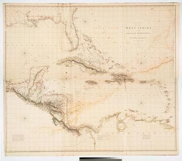
Chart of the West Indies and Spanish Dominions in North America. by A. Arrowsmith 1803. Hydrographer to H. R. H. the Prince of Wales. Additions to 1810 --1815
Visual Materials
Kashnor notes, "Amongst other interesting particulars, this map indicates the positions of the canals proposed to be cut by the Spaniards in 1528. The original issue of Arrowsmith's map, valuable for the detail regarding the coast of present-day Texas and the colonies of New Santander." Note from 105:948, another copy. Prime meridian: London. Relief: hachures. Projection: Cylindrical. Printing Process: Copper engraving. Verso Text: MS note: 715 XII XIII.
093:715 M
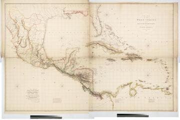
Chart of the West Indies and Spanish Dominions in North America. By A. Arrowsmith 1803
Visual Materials
Kashnor notes, "Amongst other interesting particulars, this map indicates the positions of the canals proposed to be cut by the Spaniards in 1528. The original issue of Arrowsmith's map, valuable for the detail regarding the coast of present-day Texas and the colonies of New Santander." " Jones Smith & Co. sc. Beaufort Build'gs Strand." "To Admiral John Willett Payne, A distinguished Native of the West Indies. Vice Admiral of the Coasts of Devonshire & Cornwall, Treasurer of Greenwich Hospital, Comptroller General of the Household of the Prince, &c., &c., &c. This chart is respectfully Dedicated by his most obedient Serv't A. Arrowsmith." Prime meridian: London. Relief: hachures. Projection: Cylindrical. Printing Process: Copper engraving. Verso Text: MS note: 795.
105:795 M
Image not available
Peru
Visual Materials
"Neele sculpt. 352 Strand." Submap: Coast below 16 deg.. Prime meridian: GM. Relief: hachures. Graphic Scale: Miles, leagues. Projection: Cylindrical. Printing Process: Copper engraving. Other Features: Sub-maps. Verso Text: MS note: 934.
105:934 M
Image not available
Spanish North America Southern Part
Visual Materials
RLIN record suggests 1816 publication. Prime meridian: London. Relief: hachures. Projection: Cylindrical. Printing Process: Copper engraving. Verso Text: MS note: 105/903.
105:903 M

Chart of the Isle of Trinidad From the Documents &ca. of the Spanish Vessels Employed in Surveying the Coasts of the Gulf of Mexico, 1793
Visual Materials
MS note: 840. Prime meridian: London. Relief: hachures. Projection: Cylindrical. Printing Process: Copper engraving. Verso Text: MS note: 840.
093:840 M
General Chart of the West-India Islands, With the adjacent Coasts of the Southern Continent; Including the Bay of Yucatan or Honduras. Composed from a great Variety of Surveys and Observations, Particularly those made by the Officers of the Spanish Navy. by John Purdy. Published by R. H. Laurie. Chartseller to the Admiralty, &c. &c. No. 53, Fleet Street, London. 14th June 1828. Additions &c. 1830
Visual Materials
Prime meridian: GM. Relief: hachures. Projection: Cylindrical. Printing Process: Copper engraving. Verso Text: MS note: 717.
093:717 M