Visual Materials
Peru
You might also be interested in
Image not available
United States of America Northern Part
Visual Materials
Kashnor notes, " Shows Ohio as part of Western Territory, locates Marietta or Adelphi, Zanesville or Wills Town, Fort Laurence, Chilacotha, Deleaware Town, &c." "Pinkerton's General Atlas (above neatline). Drawn under the direction of Mr. Pinkerton by T. Herbert. Neele Sculpt. 352 Strand." Prime meridian: GM. Relief: hachures. Graphic Scale: Miles, leagues. Projection: Pseudocylindrical. Printing Process: Copper engraving. Verso Text: MS note: 721.
105:721 M

St. Lucia; Done from Surveys and Observations made by the English whilst in their Possession. by Thomad Jefferys Geographer to the King. Published by Laurie & Whittle, No. 53 Fleet Street London as the Act directs 12th May, 1794
Visual Materials
Submap: Plan of Carenage.. Prime meridian: London. Relief: hachures. Graphic Scale: Leagues. Projection: Cylindrical. Printing Process: Copper engraving. Other Features: Sub-maps.
093:830 M

Carte de la Partie de l'Ocean Vers l'Equateur entre les Cotes d'Afrique et d'Amerique où la Situàtion des Isles, Bancs, et Vigies, montre qu'elles peuventêtre soit la disposition de fonds de la Mer, entre les deux Continents, soit la cause des variétés observées dans les Courants de ces Mers;
Visual Materials
Kashnor notes, "with two inset diagrams, shewing marine depths." Submap of the Island of Fernando de Noronha (Braz.) Submap of Island of Fernando de Noronha. Underwater crossectionals of ocean floor and islands.. Prime meridian: Pairs. Relief: pictorial & hachures. Graphic Scale: Leagues. Projection: Cylindrical. Watermark: Seal lettering. Printing Process: Copper engraving. Other Features: Sub-mapsArt Work. Verso Text: MS notes: 09 158.
105:158 M
Image not available
Chart of the Northern Passage between Asia & America
Visual Materials
Below neatline right: Neele, Sculp. 352 Strand. Thomson's Atlas published in Edinburgh. See map 105:016M for another copy, undated. Shows Cook's tracks 1778-1779; McKenzie's River. Minimal Compass Rose.. Prime meridian: GM. Relief: hachures. Graphic Scale: No. Projection: Cylindrical. Printing Process: Copper plate. Other Features: Explorer Tracks. Verso Text: MS note: No. 14.
093:014 M
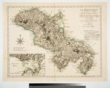
La Maretinique par les Ingenieurs Snglais lorsqui'ls en étoient possesseurs D'apres les Observations Astronomiques de M.M. de Verdun, de Borda & Pingré, Avec les Routes. Par Jefferys. A Paris, chez Charles Dien, Rue du Font St. Jacques au College de Mtre. Gervais. 1799
Visual Materials
Copy of Jeffery's map. Submap: Cul de Sac Royal. Table of astronomical observations.. Prime meridian: Ferro. Relief: hachures. Graphic Scale: Leagues. Projection: Cylindrical. Watermark: Chained maltese cross lettering. Printing Process: Copper engraving. Other Features: Sub-maps.
093:817 M
Image not available
A Chart of West Falkland Island
Visual Materials
Contains submap of other Falkland Islands. North is towards bottom of map. "from an Actual Survey by Lieut. Thos. Edgar of the Royal Navy, in the Years 1786 & 1787." "Engraved by T. Foot, Weston Place, Battle Bridge." Submap: Chart of Falkland Islands.. Prime meridian: GM. Relief: hachures. Graphic Scale: Leagues. Projection: Cylindrical. Printing Process: Copper engraving. Other Features: Sub-maps. Verso Text: MS notes: Jn. H. Coleman Falkland Island No. 3 915.
105:915 M