Visual Materials
St. Lucia; Done from Surveys and Observations made by the English whilst in their Possession. by Thomad Jefferys Geographer to the King. Published by Laurie & Whittle, No. 53 Fleet Street London as the Act directs 12th May, 1794

You might also be interested in
Ruatan or Rattan, Surveyed By Lieutenant Henry Barnsley, with Inprovements by Thomas Jefferys Geographer to the King. London: Published 12th. May 1794 by Laurie & Whittle, No. 53, Fleet Street
Visual Materials
Submaps: Old Providence and Sta. Catalina ; New Port Royal Harbour as Surveyed by Lieutenant Barnsley when the English took Possession in 1742.. Prime meridian: London. Relief: hachures. Graphic Scale: Miles, leagues. Projection: Cylindrical. Printing Process: Copper engraving. Other Features: Sub-maps. Verso Text: MS note: 823 47.
093:823 M

Martinico, Done from Actual Surveys and Observations, made by English Engineers whilst the Island was in their Possession, by Thomas Jefferys Geographer to the King
Visual Materials
Submap: Cul de Sac Royal. "VIII (upper right)" Prime meridian: Ferro. Relief: hachures. Graphic Scale: Leagues. Projection: Plane. Watermark: Crowned fleur-di-lis VI. Printing Process: Copper engraving. Other Features: Sub-maps. Verso Text: MS notes: 507 16.
105:507 M

Martinico, Done from Actual Surveys and Observations, made by English Engineers whilst the Island was in their Possession. By Thomas Jefferys Geographer to the King. Lately improved by an officer
Visual Materials
Submaps: Cul de Sac Royal; Cul de Sac Robert.. Prime meridian: Ferro. Relief: hachures. Graphic Scale: Leagues. Projection: Cylindrical. Printing Process: Copper engraving. Other Features: Sub-maps. Verso Text: MS note: 812.
093:812
Image not available
New and General Map of the Southern Dominions belonging to the United States of America, viz. North Carolina, South Carolina and Georgia: with the Bordering Indian Countries, and the Spanish Possessions of Louisiana and Florida. London Published by Laurie & Whittle, No. 53 Fleet Street, As the Act directs 12th May 1794
Visual Materials
Two submaps. Submaps: Plan of Charlestown; Plan of St. Augustine. Prime meridian: London. Relief: pictorial. Graphic Scale: Miles, leagues. Projection: Azimuthal. Printing Process: Copper engraving. Other Features: Sub-maps.
093:434 M
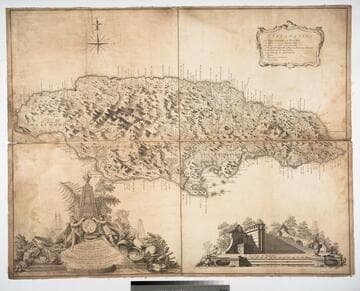
Jamaica from the latest surveys; Improved and Engraved by Thomas Jefferys Geographer to the King
Visual Materials
Two insert maps.See also 093:796M for a later version. Submap: Harbour of Bluefields; Harbour of Kingston aand Port Royal.. Prime meridian: London, Ferro. Relief: hachures. Graphic Scale: Miles, leagues. Projection: Cylindrical. Printing Process: Copper engraving. Other Features: Sub-maps. Verso Text: MS note: 795.
093:795 M

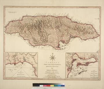
Jamaica from the latest surveys; Improved and Engraved by Thomas Jefferys Geographer to the King
Visual Materials
Two insert maps. See also 093:795M for an earlier version. Submap: Anchorage at Savanna la Mar & Bluefields; Harbour of Kingston aand Port Royal.. Prime meridian: GM. Relief: hachures. Graphic Scale: Miles, leagues. Projection: Cylindrical. Printing Process: Copper engraving. Other Features: Sub-maps. Verso Text: MS note: 796.
093:796 M