Visual Materials
New and General Map of the Southern Dominions belonging to the United States of America, viz. North Carolina, South Carolina and Georgia: with the Bordering Indian Countries, and the Spanish Possessions of Louisiana and Florida. London Published by Laurie & Whittle, No. 53 Fleet Street, As the Act directs 12th May 1794
You might also be interested in

General Map of the Southern British Colonies in America. Comprehending North and South Carolina, Georgia, East and West Florida, with the Neighboring Indian Countries. From the Modern Surveys of Engineer de Brahm, Capt. Collet, Mouzon & Others and from the Large Hydrographical Survey of the Coasts of East and West Florida. By B. Romans, 1776
Visual Materials
Kashnor notes, "A valuable map, showing the main roads, issued during the early part of the American Revolution." Framed cartouche, submaps of Charlestown (sic) and St. Augustine.. Prime meridian: London. Relief: pictorial. Graphic Scale: Miles, leagues. Projection: Pseudocylindrical. Watermark: Crowned fleur-di-lis. Printing Process: Copper engraving. Other Features: Sub-mapsCartouche. Verso Text: MS note: 70.
093:070 M
Ruatan or Rattan, Surveyed By Lieutenant Henry Barnsley, with Inprovements by Thomas Jefferys Geographer to the King. London: Published 12th. May 1794 by Laurie & Whittle, No. 53, Fleet Street
Visual Materials
Submaps: Old Providence and Sta. Catalina ; New Port Royal Harbour as Surveyed by Lieutenant Barnsley when the English took Possession in 1742.. Prime meridian: London. Relief: hachures. Graphic Scale: Miles, leagues. Projection: Cylindrical. Printing Process: Copper engraving. Other Features: Sub-maps. Verso Text: MS note: 823 47.
093:823 M

St. Lucia; Done from Surveys and Observations made by the English whilst in their Possession. by Thomad Jefferys Geographer to the King. Published by Laurie & Whittle, No. 53 Fleet Street London as the Act directs 12th May, 1794
Visual Materials
Submap: Plan of Carenage.. Prime meridian: London. Relief: hachures. Graphic Scale: Leagues. Projection: Cylindrical. Printing Process: Copper engraving. Other Features: Sub-maps.
093:830 M
![Seat of the War, in New England, by an American Volunteer [Submap]: Plan of the Town of Boston with the Attack on Bunkers-Hill in the Peninsula of Charlestown, the 17th. of June 1775. With the Marches of the Several Corps Sent by the Colonies. Towards Boston. with the Attack on Bunkers = Hill](/_next/image?url=https%3A%2F%2Frail.huntington.org%2FIIIF3%2FImage%2F22APN4KOYJI7%2Ffull%2F%5E360%2C%2F0%2Fdefault.jpg&w=750&q=75)
Seat of the War, in New England, by an American Volunteer [Submap]: Plan of the Town of Boston with the Attack on Bunkers-Hill in the Peninsula of Charlestown, the 17th. of June 1775. With the Marches of the Several Corps Sent by the Colonies. Towards Boston. with the Attack on Bunkers = Hill
Visual Materials
Kashnor notes, "A very fine and rare war plan, with both imprints. The Bunker's Hill plan shows Charlestown in flames." Two submaps: Plan of Boston Harbour from an Actual Survey. Plan of the Town of Boston.... Prime meridian: London. Relief: hachures. Graphic Scale: Miles, English. Projection: Cylindrical. Watermark: Crowned fluer-di-lis (half). Printing Process: Copper engraving. Other Features: Sub-maps. References: McCorkle 775.1. Verso Text: MS note: 128.
093:128 M

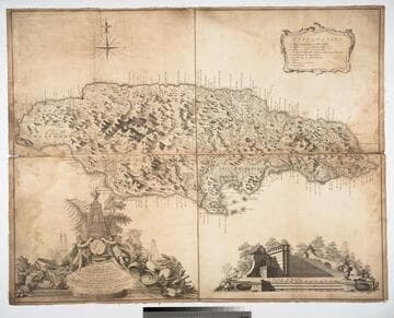
New & Accurate Map of the Island of Jamaica Divided into its Parishes, Containing theTowns, Plantations, Forts, Capes, Bays, &c. from all the Surveys made there of the Year 1755
Visual Materials
Two submaps. Submap: The Harbour of Port-Royal; Particular Plan of Port Royal before the Earthquake in 1692 and after the present year of 1755. . Prime meridian: London. Relief: pictorial. Graphic Scale: Miles. Projection: Cylindrical. Printing Process: Copper engraving. Other Features: Sub-maps.
093:800 M

Carte de l'Isle de Sainte Lucie Dressée au Dépost des Cartes et Plans de la Marine pour le Service des Vaisseaux du Roy. Par Ordre de M. le Duc de Choiseul Colonel General des Suisses et Grisons, Ministre de la Guerre et de la Marine. Par le Srt. Bellin Ingineur de la Marine. 1763
Visual Materials
Submaps: Plan du Port de Carnage: Pla du Cul de Sac des Roseaux; Mouillages du Grand Islet du Choc. Cartouche: pillared with Royal Crown.. Prime meridian: Paris. Relief: pictorial. Graphic Scale: Leagues, toises. Projection: Cylindrical. Watermark: Two headed bird Fin Suav -Vero. Printing Process: Copper engraving. Other Features: Sub-maps. Verso Text: MS note: 829.
093:829 M