Visual Materials
Ruatan or Rattan, Surveyed By Lieutenant Henry Barnsley, with Inprovements by Thomas Jefferys Geographer to the King. London: Published 12th. May 1794 by Laurie & Whittle, No. 53, Fleet Street

You might also be interested in

Ruatan ou Rattan
Visual Materials
Includes two submaps. This island is located in the Gulf of Honduras. Submaps: Vielle Providence et Sta. Catalina [de Providencia Island]; Port de Nouveau Part Royal. Text in French describing the history of this island.. "levé Par Henry Barnsley Lieutenant Augmenté par Jefferys en 1775. Traduit de l'Anglais." Prime meridian: London. Relief: hachures. Graphic Scale: Leagues, miles. Projection: Plane. Watermark: Chained maltese cross lettering. Printing Process: Copper engraving. Other Features: Sub-maps. Verso Text: MS note: 773.
105:773 M
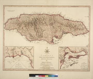
Jamaica from the latest surveys; Improved and Engraved by Thomas Jefferys Geographer to the King
Visual Materials
Two insert maps.See also 093:796M for a later version. Submap: Harbour of Bluefields; Harbour of Kingston aand Port Royal.. Prime meridian: London, Ferro. Relief: hachures. Graphic Scale: Miles, leagues. Projection: Cylindrical. Printing Process: Copper engraving. Other Features: Sub-maps. Verso Text: MS note: 795.
093:795 M

St. Lucia; Done from Surveys and Observations made by the English whilst in their Possession. by Thomad Jefferys Geographer to the King. Published by Laurie & Whittle, No. 53 Fleet Street London as the Act directs 12th May, 1794
Visual Materials
Submap: Plan of Carenage.. Prime meridian: London. Relief: hachures. Graphic Scale: Leagues. Projection: Cylindrical. Printing Process: Copper engraving. Other Features: Sub-maps.
093:830 M

Jamaica from the latest surveys; Improved and Engraved by Thomas Jefferys Geographer to the King
Visual Materials
Two insert maps. See also 093:795M for an earlier version. Submap: Anchorage at Savanna la Mar & Bluefields; Harbour of Kingston aand Port Royal.. Prime meridian: GM. Relief: hachures. Graphic Scale: Miles, leagues. Projection: Cylindrical. Printing Process: Copper engraving. Other Features: Sub-maps. Verso Text: MS note: 796.
093:796 M
Image not available
New and General Map of the Southern Dominions belonging to the United States of America, viz. North Carolina, South Carolina and Georgia: with the Bordering Indian Countries, and the Spanish Possessions of Louisiana and Florida. London Published by Laurie & Whittle, No. 53 Fleet Street, As the Act directs 12th May 1794
Visual Materials
Two submaps. Submaps: Plan of Charlestown; Plan of St. Augustine. Prime meridian: London. Relief: pictorial. Graphic Scale: Miles, leagues. Projection: Azimuthal. Printing Process: Copper engraving. Other Features: Sub-maps.
093:434 M

Virgin Islands from English and Danish Surveys, bt Thomas Jefferys Geographer to the King Corrected and Improved by Captain James Waring 1797
Visual Materials
Submaps: Plan of Peters Island; Harbour or Road to Tortola. Vignettes: (11) views of islands from shipboard.. Prime meridian: London. Relief: hachures. Graphic Scale: Miles, leagues. Projection: Cylindrical. Printing Process: Copper engraving. Other Features: VignettesSub-maps. Verso Text: MS note: 842.
093:842 M