Visual Materials
Virgin Islands from English and Danish Surveys, bt Thomas Jefferys Geographer to the King Corrected and Improved by Captain James Waring 1797

You might also be interested in

Barbadoes, Surveyed by William Mayo, Engraved and Improved by Thomas Jefferys, Geographer to the King
Visual Materials
Vignettes: Two views of island from shipboard.. Prime meridian: London. Relief: hachures. Graphic Scale: Miles, leagues. Projection: Plane. Printing Process: Copper engraving. Other Features: Vignettes. Verso Text: MS note: 747.
093:747 M
Image not available
Chart of the River la Plata, from its Mouth up to Buenos-Ayres. Surveyed by Order of the King of Spain in the Year 1789. Revised and corrected in 1794, by several Officers of the Royal Navy
Visual Materials
Shows tracks and soundings of HMS Diomede and Leda for Second edition, and HMS Woolwich for Third Edition information. Vignettes: View of the coast between Point of la Sierra & that of la Ballena/ the Whale: view of the Island of Lobos/ Sea Wolf Island. Submaps: Plan of the Harbour of Maldanado, On the North Shore of River La Plata, at its mouth, Surveyed in 1789: Plan of the Harbour of Montivedeo, on the North Shore of the River La Plata, Surveyed in the Year 1789.. Prime meridian: GM, Cadiz. Relief: hachures. Graphic Scale: Leagues. Projection: Cylindrical. Printing Process: Copper engraving. Other Features: VignettesSub-maps. Verso Text: MS notes: 637 23.
093:637 M

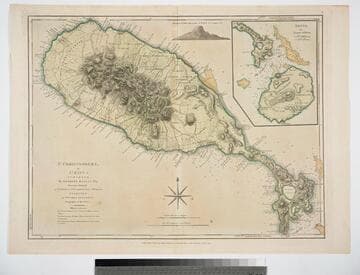
St. Christophers, or St. Kitts, surveyed By Anthony Ravell Esqr. Surveyor General of the Islands of St. Christophers, Nevis, & Montserrat. Engraved by Thomas Jefferys Geographer to the King
Visual Materials
See 093:827M for an earlier copy. Vignette: Nevis from shipboard Submap: Nevis, by Thomas Jefferys.. Prime meridian: London, Ferro. Relief: hachures. Graphic Scale: Miles, leagues. Projection: Cylindrical. Printing Process: Copper engraving. Other Features: VignettesSub-maps. Verso Text: MS notes: 828.
093:828 M

Antigua, Surveyed by Robert Baker, Survetor General of that Island: Engraved and IOmproved by Thomas Jefferys, Geographer to the King
Visual Materials
Submap: English Harbour. Vignette: Island view from sea.. Prime meridian: London, Ferro. Relief: hachures. Graphic Scale: Miles, leagues. Projection: Plane. Printing Process: Copper engraving. Other Features: VignettesSub-maps. Verso Text: MS notes: 738 32.
093:738 M
St. Christophers, or St. Kitts, surveyed By Anthony Ravell Esqr. Surveyor General of the Islands of St. Christophers, Nevis, & Montserrat. Engraved by Thomas Jefferys Geographer to the King
Visual Materials
See 093:828M for a later copy. Vignette: Nevis from shipboard Submap: Nevis, by Thomas Jefferys.. Prime meridian: London, Ferro. Relief: hachures. Graphic Scale: Miles, leagues. Projection: Cylindrical. Watermark: Crowned fluer-di-lid TW. Printing Process: Copper engraving. Other Features: VignettesSub-maps. Verso Text: MS notes: 827 43.
093:827 M
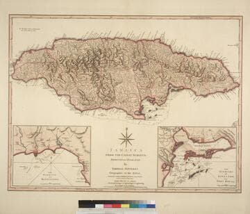
Jamaica from the latest surveys; Improved and Engraved by Thomas Jefferys Geographer to the King
Visual Materials
Two insert maps.See also 093:796M for a later version. Submap: Harbour of Bluefields; Harbour of Kingston aand Port Royal.. Prime meridian: London, Ferro. Relief: hachures. Graphic Scale: Miles, leagues. Projection: Cylindrical. Printing Process: Copper engraving. Other Features: Sub-maps. Verso Text: MS note: 795.
093:795 M