Visual Materials
Chart of the River la Plata, from its Mouth up to Buenos-Ayres. Surveyed by Order of the King of Spain in the Year 1789. Revised and corrected in 1794, by several Officers of the Royal Navy
You might also be interested in
Image not available
Chart of Rio de la Plata, from an Actual Survey
Visual Materials
Kashnor notes, "Shows the course of the la Plata to above Buenos Ayres at Port Carroras." Prime meridian: GM. Relief: pictorial. Projection: Mercator. Printing Process: Copper engraving. Verso Text: MS note: 636.
093:636 M
Image not available
A New and Accurate Chart (from Captain Holland's Surveys) of the North American Coast, for the Navigation between Cape Cod in New England, and the Havanna in the Gulf of Florida
Visual Materials
Submaps of harbors, tables, remarks. This is an earlier edition of RLIN record NYPGR45193985-M. MS notes: 159-160 Submaps: Plan of the Entrance and Harbour of St. Augustin; Plan of the Mouth of the Nassau River; Plan of the Inlet of the St. Mary's River;Plan of the Harbour of Port Royal; Plan of the Bar and Harbour of Charleston; Chart of New York Harbour. Tables of sailing directions. Remarks on Lighthouses.. "Respectfully Inscribed To the Honourable Thomas Jefferson, Vice President of the United States of North America By his most obedient humble Servants, Rt. Laurie & J. Whittle. Fleet Street 1800." "MS note in red: Note. This Chart is accompanied by the Book entitled "Laurie and Whittle's New Sailing Directions for the Coasts and Harbours of North America. An Inproved Edition. 1809." Prime meridian: London. Relief: pictorial. Projection: Mercator. Printing Process: Copper engraving. Other Features: Sub-maps. Verso Text: MS note: 537.
105:537 M
Image not available
New and Correct Chart from Captain Holland's Surveys, of the North-American Coast for the Navigation between Halifax and Philadelphia
Visual Materials
Kashnor notes, "With inset charts of New York Harbour, Boston Harbour, and plan of Halifax Harbour and small engravings of landmarks for bearings on entering New York Harbour at Sandy Hook. A very rare chart, dedicated to John Adams." Submaps of New York Harbour, Boston Harbour and Halifax Harbour. Coastal views of Bond Hollow, Mount Pleasant, Banabeag Hills, Cape Ann, Block Island, Mt. Desert Land, Chebucto Head. MS note: 158. Prime meridian: GM. Relief: no. Projection: Mercator. Printing Process: Copper engraving. Other Features: Sub-maps. Verso Text: MS notes: 274 4 sheets..
093:274 M
Image not available
A Chart of the West Coast of Newfoundland, Surveyed by Order of Commodore Palliser, Governor of Newfoundland, Labrador, &c. &c. by James Cook, Surveyor
Visual Materials
Kashnor notes, "A scarce issue of Cook's famous chart." James Cook, later Captain James Cook, held the position of surveyor under Newfoundland's Governor Palliser between 1763 and 1767. See also 105:554M for another copy dated 1794. Submaps: Plan of Hawkes Harbour, Port Saunders and Keppel Harbour. Plan of York and Lark Harbours, in the Bay of Islands. Five views from ships anchored offshore.. Prime meridian: London. Relief: hachures. Graphic Scale: Leagues. Projection: Cylindrical. Printing Process: Copper engraving. Other Features: Sub-maps.
093:256 M
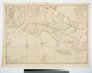
A New & Correct Chart of Cuba, Streights of Bahama, Windward Passage, the Current through the Gulf of Florida, with the Soundings &c. By an Officer in the Navy
Visual Materials
Kashnor dates as ca. 1740. Sub-map: A Plan of the Harbour & Town of Havana. Prime meridian: London. Relief: pictorial. Projection: Mercator. Printing Process: Copper engraving. Other Features: Sub-maps. Verso Text: MS note: 381.
105:381 M
Image not available
New Map of the North Parts of America claimed by France under the Names of Louisiana, Mississipi, Canada and New France with the adjoining Territories of England and Spain
Visual Materials
Kashnor notes, "Shows the far west taken from a French map, and locates a fairly correct course of the Missouri, notes La Hontan's limit ending in the Great Lake, and gives a good map of New Mexico, with the City of Santa Fe. A rare early western map." View of Indian fort of Sasquesahanck. Two submaps. Scale for determining distance on a Mercator scale map. McLaughlin identifies this as first edition. Submaps: Map of the Mouth of the Mississipi & Mobile Rivers, &c.; Harbour of Annapolis Royal. Vignette: The Indian Fort at Sasquesahanok. Bromsall coat of arms.. Prime meridian: London. Relief: pictorial. Graphic Scale: Miles. Projection: Mercator. Printing Process: Copper engraving. Other Features: VignettesSub-maps. References: McLaughlin 197.. Verso Text: MS note: No. 9.
093:468 M