Visual Materials
New & Accurate Map of the Island of Jamaica Divided into its Parishes, Containing theTowns, Plantations, Forts, Capes, Bays, &c. from all the Surveys made there of the Year 1755

You might also be interested in
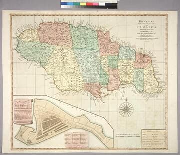
Bowles's New One-Sheet Map of Jamaica, Divided into its Parishes, &c. from the Actual Surveys of Sheffield and others
Visual Materials
Submap: General plan of Port Royal [showing before and after earthquake dimensions].. Prime meridian: London. Relief: pictorial. Graphic Scale: Miles. Projection: Cylindrical. Printing Process: Copper engraving. Other Features: Sub-maps. Verso Text: MS note: 788.
093:788 M

A new map of the island of Jamaica : divided into its parishes including the south end of Cuba and the west end of Hispaniola with the trade winds &c / drawn from the best surveys by Thos. Kitchin Geogr
Visual Materials
Two submaps. Kashnor dates as ca. 1780. Jolly notes London Magazine publication date as July 1763. Duplicate of 105:461. Submaps: Chart of the Windward Passage; Plan of Port Royal Harbour. MS note: 461 (on backing). Prime meridian: London. Relief: pictorial. Graphic Scale: Miles. Projection: Cylindrical. Printing Process: Copper engraving. Other Features: Sub-maps. References: Jolly Brit. Period. LOND-228.
105:460 M

New Map of the Island of Jamaica Divided into its Parishes Including the South End of Cuba and the West End of Hispaniola with the Trade Winds &c. Drawn from the best Surveys by Thos. Kitchin Geogr
Visual Materials
Two submaps. Kashnor dates as ca. 1780. Jolly notes London Magazine publication date as July 1763. Duplicate of 105:460. Submaps: Chart of the Windward Passage; Plan of Port Royal Harbour. MS note: 460 (on backing). Prime meridian: London. Relief: pictorial. Graphic Scale: Miles. Projection: Cylindrical. Printing Process: Copper engraving. Other Features: Sub-maps. References: Jolly Brit. Period. LOND-228.
105:461 M
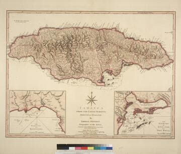
Jamaica from the latest surveys; Improved and Engraved by Thomas Jefferys Geographer to the King
Visual Materials
Two insert maps.See also 093:796M for a later version. Submap: Harbour of Bluefields; Harbour of Kingston aand Port Royal.. Prime meridian: London, Ferro. Relief: hachures. Graphic Scale: Miles, leagues. Projection: Cylindrical. Printing Process: Copper engraving. Other Features: Sub-maps. Verso Text: MS note: 795.
093:795 M
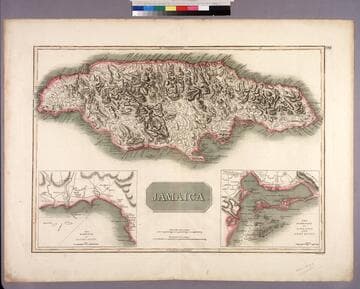
Jamaica
Visual Materials
Two submaps. Submaps: The Harbour of Bluefields; The Harbour of Kingston and Port Royal.. Prime meridian: London, Ferro. Relief: hachures. Graphic Scale: Miles. Projection: Cylindrical. Printing Process: Copper engraving. Other Features: Sub-maps. Verso Text: MS note: 456.
105:456 M
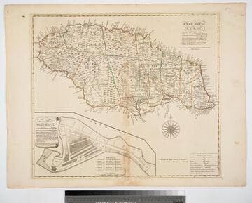
New Map of Jamaica In which the Several Towns Forts & Settlements are Accurately laid down, as well as the situations & depths of the most noted Harbours and Anchoring Places, with the limits and boundaries of the different Parishes, as they have been regulated by Law, or settled by Custom, the greatest part Drawn or Corrected from actual Surveys Made by Mr. Sheffield and others
Visual Materials
Submap: General Plan of Port Royal in which Different States of the Town are Accurately laid Down. . Prime meridian: London. Relief: pictorial. Graphic Scale: Miles. Projection: Cylindrical. Watermark: Crowned fleur-di-lis IV. Printing Process: Copper engraving. Other Features: Sub-maps. Verso Text: MS notes: 801 J5..
093:801 M