Visual Materials
Jamaica

You might also be interested in
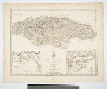
La Jamaique Dresée sur les deniers Plans par Jefferys. Traduite de l'Anglois
Visual Materials
Two submaps. Submaps: Le Port de Bluefields; Les Ports de Kingston et Port Royal.. Prime meridian: London, Ferro. Relief: hachures. Graphic Scale: Miles. Projection: Cylindrical. Printing Process: Copper engraving. Other Features: Sub-maps. Verso Text: MS note: 457.
105:457 M
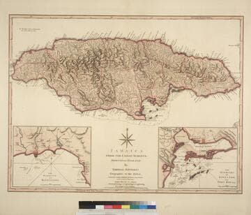
Jamaica from the latest surveys; Improved and Engraved by Thomas Jefferys Geographer to the King
Visual Materials
Two insert maps.See also 093:796M for a later version. Submap: Harbour of Bluefields; Harbour of Kingston aand Port Royal.. Prime meridian: London, Ferro. Relief: hachures. Graphic Scale: Miles, leagues. Projection: Cylindrical. Printing Process: Copper engraving. Other Features: Sub-maps. Verso Text: MS note: 795.
093:795 M

Jamaica from the latest surveys; Improved and Engraved by Thomas Jefferys Geographer to the King
Visual Materials
Two insert maps. See also 093:795M for an earlier version. Submap: Anchorage at Savanna la Mar & Bluefields; Harbour of Kingston aand Port Royal.. Prime meridian: GM. Relief: hachures. Graphic Scale: Miles, leagues. Projection: Cylindrical. Printing Process: Copper engraving. Other Features: Sub-maps. Verso Text: MS note: 796.
093:796 M

New & Accurate Map of the Island of Jamaica Divided into its Parishes, Containing theTowns, Plantations, Forts, Capes, Bays, &c. from all the Surveys made there of the Year 1755
Visual Materials
Two submaps. Submap: The Harbour of Port-Royal; Particular Plan of Port Royal before the Earthquake in 1692 and after the present year of 1755. . Prime meridian: London. Relief: pictorial. Graphic Scale: Miles. Projection: Cylindrical. Printing Process: Copper engraving. Other Features: Sub-maps.
093:800 M

A new map of the island of Jamaica : divided into its parishes including the south end of Cuba and the west end of Hispaniola with the trade winds &c / drawn from the best surveys by Thos. Kitchin Geogr
Visual Materials
Two submaps. Kashnor dates as ca. 1780. Jolly notes London Magazine publication date as July 1763. Duplicate of 105:461. Submaps: Chart of the Windward Passage; Plan of Port Royal Harbour. MS note: 461 (on backing). Prime meridian: London. Relief: pictorial. Graphic Scale: Miles. Projection: Cylindrical. Printing Process: Copper engraving. Other Features: Sub-maps. References: Jolly Brit. Period. LOND-228.
105:460 M

New Map of the Island of Jamaica Divided into its Parishes Including the South End of Cuba and the West End of Hispaniola with the Trade Winds &c. Drawn from the best Surveys by Thos. Kitchin Geogr
Visual Materials
Two submaps. Kashnor dates as ca. 1780. Jolly notes London Magazine publication date as July 1763. Duplicate of 105:460. Submaps: Chart of the Windward Passage; Plan of Port Royal Harbour. MS note: 460 (on backing). Prime meridian: London. Relief: pictorial. Graphic Scale: Miles. Projection: Cylindrical. Printing Process: Copper engraving. Other Features: Sub-maps. References: Jolly Brit. Period. LOND-228.
105:461 M