Visual Materials
New Map of Jamaica In which the Several Towns Forts & Settlements are Accurately laid down, as well as the situations & depths of the most noted Harbours and Anchoring Places, with the limits and boundaries of the different Parishes, as they have been regulated by Law, or settled by Custom, the greatest part Drawn or Corrected from actual Surveys Made by Mr. Sheffield and others

You might also be interested in
Image not available
An Exact Plan of Charleston Bar and Harbour. From an Actual Survey. With the attack of Fort Sulivan, on the 28th of June 1776. by His Majesty's Squadron. Commanded by Sir Peter Parker
Visual Materials
Kashnor notes, "Indicates the vessels engaged, giving partuculars of their guns, commanders, and casualties. A very fine plan." Relief: no. Graphic Scale: Miles. Projection: Plane. Watermark: Crowned fleur-di-lis VI. Printing Process: Copper engraving. Verso Text: 8 MS note: 319.
105:319 M
Image not available
Quebek De Hoofstad van Kanada; aan de Rivier van St.Laurens: door de Engelschen belegero en by Verdrag bemagtigd, in't jaar 1759
Visual Materials
Kashnor notes, " A rare Dutch plan of the fall of Quebec." Submap of St. Lawrence River. Another copy of Jefferys map, see 093:328, etc. Kashnor dates as circa 1760. Submap: De Rivier boven Quebek.. Relief: hachures. Graphic Scale: Miles. Projection: Plane. Watermark: Crowned fleur-di-lis Van Der Ley. Printing Process: Copper engraving. Other Features: CartoucheSub-maps. Verso Text: MS note: 330.
093:330 M

Accurate Map of North and South Carolina with their Indian Frontiers, showing in a distinct manner all the Mountains, Rivers, Swamps, Marshes, Bays, Creeks, Harbours, Sandbanks and Soundings on the Coast, with the Roads and Indian Paths as well as the Boundary or Provincial Lines, the Several Townships and other divisions of the Land in Both the Provinces; the whole from Actual Surveys by Henry Mouzon and others
Visual Materials
Noted as duplicate of 192531, 29-30 and 2813, #73-74. Submap: Harbour at Port Royal; Bar and Harbour of Charlestown.. Prime meridian: London. Relief: hachures. Projection: Cylindrical. Watermark: Crowned fluer-di-lis VI. Printing Process: Copper engraving. Other Features: Sub-maps. Verso Text: MS note: 73 H. E. H. Dupl. stamp..
105:073 M

Martinico, Done from Actual Surveys and Observations, made by English Engineers whilst the Island was in their Possession, by Thomas Jefferys Geographer to the King
Visual Materials
Submap: Cul de Sac Royal. "VIII (upper right)" Prime meridian: Ferro. Relief: hachures. Graphic Scale: Leagues. Projection: Plane. Watermark: Crowned fleur-di-lis VI. Printing Process: Copper engraving. Other Features: Sub-maps. Verso Text: MS notes: 507 16.
105:507 M

Spry Harbor, Port Pallisser, Port North, Port Parker, Beaver Harbour, entrance to Fleming River
Visual Materials
Kashnor notes, "A fine and rare chart by J. F. W. Des Barres." Gives sailing directions for entering each port. View of land from Cape Spry to westernmost ledge of Pegasus Wing.. Prime meridian: GM. Relief: pictorial. Graphic Scale: Miles, statute. Projection: Mercator. Watermark: Crowned fleur-di-lis V I. Printing Process: Copper engraving. Other Features: Vignettes. Verso Text: Ms note: 116.
093:116 M
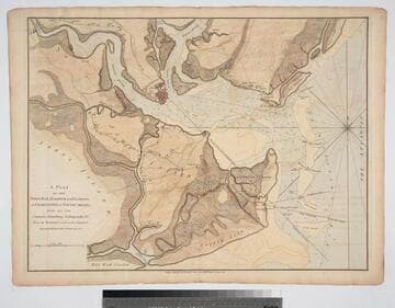
Plan of the Town, Bar, Harbour and Environs, of Charlestown in South Carolina, with all the Channels, Soundings, Sailing-marks &c. From the Surveys made in the Colony Engraved by William Faden, Charing Cross, 1780
Visual Materials
Kashnor notes, "A very scarce plan issued for use during the American Revolution." Atlas reference from The American Revolution 1775-1783, Naval History Division, Department of the Navy, Washington, 1972. Huntington f G1202 S3U5. Compass Rose. Relief: hachures. Graphic Scale: Miles. Projection: Cylindrical. Watermark: Crowned fleur-di-lis. Printing Process: Copper engraving.
093:082 M