Visual Materials
Plan of the Town, Bar, Harbour and Environs, of Charlestown in South Carolina, with all the Channels, Soundings, Sailing-marks &c. From the Surveys made in the Colony Engraved by William Faden, Charing Cross, 1780

You might also be interested in
Image not available
Chart of the Harbour of Boston, with the Soundings, Sailing-Marks and Other Directions
Visual Materials
Kashnor notes, "From the indications, Ruins of Charlestown, this map must have been executed about 1776." RLIN record suggests ca. 1777 and give publisher information. This map may be a source map for 105:064M. Relief: hachures. Graphic Scale: Miles, nautical. Projection: Plane. Watermark: Crowned fleur-di-lis. Printing Process: Copper engraving. Verso Text: MS notes: 65 2.
105:065 M

Chart of the Entrance to Hudson's River, from Sandy Hook to New York, with the Banks, Depths of Water, Sailing-marks, &ca
Visual Materials
Kashnor notes, "A scarce chart, issued during the early period of the American Revolution." Found in North-American pilot for New England, New York, Pensilvania (sic), Maryland, and Virginia 1777, per RLIN record. Relief: hachures. Graphic Scale: Miles, English. Projection: Plane. Watermark: Crowned fleur-di-lis. Printing Process: Copper engraving. References: Phillips 1209. Verso Text: MS note: 105.
093:105 M

Plan of Cape Fear River from the Bar to Brunswick
Visual Materials
Kashnor notes, "A rare chart issued for use during the American Revolution." Shows Fort Johnston and harbor. Gives sailing directions for entering Cape Fear River. Prime meridian: London. Relief: pictorial. Graphic Scale: Leagues, miles. Projection: Cylindrical. Watermark: Crowned fleur-di-lis. Printing Process: Copper engraving. Verso Text: MS note: 78.
093:078 M
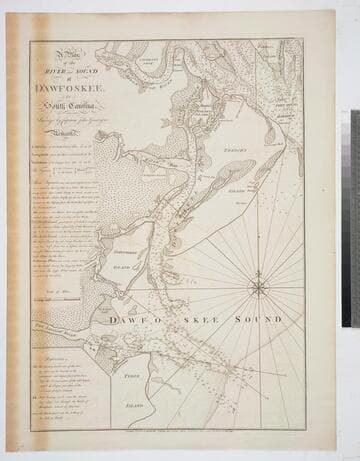
A Plan of the River and Sound of D'Awfoskee, in South Carolina. Survey'd by Captain John Gascoigne
Visual Materials
MS note: c 36. Prime meridian: London. Relief: no. Graphic Scale: Miles. Projection: Plane. Watermark: Crowned fleur-di-lis VI. Printing Process: Copper engraving. Verso Text: MS note: 349 10.
105:349 M

Plan of the Operations of the King's Army under the Command of General Sr. William HoWe, K.B. in NeW York and East NeW Jersey, against the American Forces Commanded by General Washington, From the 12th. of October, to the 28th. of November 1776
Visual Materials
Kashnor notes, "An exceedingly rare plan of one of the most famous engagements during the American Revolution." Relief: hachures. Graphic Scale: Miles. Projection: Plane. Watermark: CroWned fleur-di-lis W F. Printing Process: Copper engraving. Verso Text: MS notes: 109 JS.
093:109 M
![[Chart of Narraganset Bay from Newport to Providence]](/_next/image?url=https%3A%2F%2Frail.huntington.org%2FIIIF3%2FImage%2F22APN4KO5SV7%2Ffull%2F%5E360%2C%2F0%2Fdefault.jpg&w=750&q=75)
[Chart of Narraganset Bay from Newport to Providence]
Visual Materials
Kashnor notes, "A fine chart, issued during the American Revolution, giving a particularly good map of Rhode Island." Prime meridian: GM. Relief: pictorial & hachures. Graphic Scale: Miles, statute. Projection: Cylindrical. Watermark: Crowned fleur-di-lis. Printing Process: Copper engraving. Verso Text: MS note: 125.
093:125 M