Visual Materials
[Chart of Narraganset Bay from Newport to Providence]

You might also be interested in
Image not available
Gut of Canso, which divides the Island of Cape Breton from the Continent of Nova Scotia
Visual Materials
Kashnor notes, " A long chart with sailing directions, very rare." Text with sailing directions.. Prime meridian: GM. Relief: pictorial. Graphic Scale: Miles, statute & nautical. Projection: Cylindrical. Watermark: Crowned fleur-di-lis. Printing Process: Copper engraving. Verso Text: MS note: 117.
093:117 M
![[Chart of Nantucket Island and the eastern half of Martha's Vineyard]](/_next/image?url=https%3A%2F%2Frail.huntington.org%2FIIIF3%2FImage%2F22APN4KO49P5%2Ffull%2F%5E360%2C%2F0%2Fdefault.jpg&w=750&q=75)
[Chart of Nantucket Island and the eastern half of Martha's Vineyard]
Visual Materials
Title supplied by cataloger. Kashnor notes, "A rare chart, giving a fine map of Nantucket Island and part of Martha's Vineyard. It was issued at a critical time during the American Revolution, when the passage would be resorted to in case of Boston Harbour not being available." Map contains sailing and anchoring instructions and fine map of Chapaquidick Island. Place of publication: Des Barres was known to work in London. Folded once.. Prime meridian: GM. Relief: pictorial & hachures. Graphic Scale: Miles, statute & nautical. Projection: Cylindrical. Watermark: Crowned fleur-di-lis over LCV J Bates. Printing Process: Copper engraving. Verso Text: MS notes: 100 19.
093:100 M

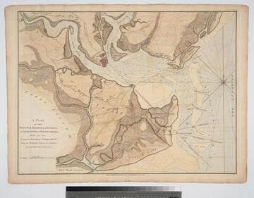
Plan of Cape Fear River from the Bar to Brunswick
Visual Materials
Kashnor notes, "A rare chart issued for use during the American Revolution." Shows Fort Johnston and harbor. Gives sailing directions for entering Cape Fear River. Prime meridian: London. Relief: pictorial. Graphic Scale: Leagues, miles. Projection: Cylindrical. Watermark: Crowned fleur-di-lis. Printing Process: Copper engraving. Verso Text: MS note: 78.
093:078 M

Chart of the Entrance to Hudson's River, from Sandy Hook to New York, with the Banks, Depths of Water, Sailing-marks, &ca
Visual Materials
Kashnor notes, "A scarce chart, issued during the early period of the American Revolution." Found in North-American pilot for New England, New York, Pensilvania (sic), Maryland, and Virginia 1777, per RLIN record. Relief: hachures. Graphic Scale: Miles, English. Projection: Plane. Watermark: Crowned fleur-di-lis. Printing Process: Copper engraving. References: Phillips 1209. Verso Text: MS note: 105.
093:105 M

Spry Harbor, Port Pallisser, Port North, Port Parker, Beaver Harbour, entrance to Fleming River
Visual Materials
Kashnor notes, "A fine and rare chart by J. F. W. Des Barres." Gives sailing directions for entering each port. View of land from Cape Spry to westernmost ledge of Pegasus Wing.. Prime meridian: GM. Relief: pictorial. Graphic Scale: Miles, statute. Projection: Mercator. Watermark: Crowned fleur-di-lis V I. Printing Process: Copper engraving. Other Features: Vignettes. Verso Text: Ms note: 116.
093:116 M
Plan of the Town, Bar, Harbour and Environs, of Charlestown in South Carolina, with all the Channels, Soundings, Sailing-marks &c. From the Surveys made in the Colony Engraved by William Faden, Charing Cross, 1780
Visual Materials
Kashnor notes, "A very scarce plan issued for use during the American Revolution." Atlas reference from The American Revolution 1775-1783, Naval History Division, Department of the Navy, Washington, 1972. Huntington f G1202 S3U5. Compass Rose. Relief: hachures. Graphic Scale: Miles. Projection: Cylindrical. Watermark: Crowned fleur-di-lis. Printing Process: Copper engraving.
093:082 M