Visual Materials
Plan of Cape Fear River from the Bar to Brunswick

You might also be interested in
Image not available
A Plan of Cape Fear River from the Bar to Brunswick
Visual Materials
Kashnor notes, "A very scarce chart. It was reissued in 1800 by Laurie & Whittle." MS note: c 38. Prime meridian: London. Relief: no. Graphic Scale: Miles. Projection: Plane. Watermark: Crowned fleur-di-lis VI. Printing Process: Copper engraving. Verso Text: MS notes: 347 7.
105:347 M

Spry Harbor, Port Pallisser, Port North, Port Parker, Beaver Harbour, entrance to Fleming River
Visual Materials
Kashnor notes, "A fine and rare chart by J. F. W. Des Barres." Gives sailing directions for entering each port. View of land from Cape Spry to westernmost ledge of Pegasus Wing.. Prime meridian: GM. Relief: pictorial. Graphic Scale: Miles, statute. Projection: Mercator. Watermark: Crowned fleur-di-lis V I. Printing Process: Copper engraving. Other Features: Vignettes. Verso Text: Ms note: 116.
093:116 M
Image not available
Gut of Canso, which divides the Island of Cape Breton from the Continent of Nova Scotia
Visual Materials
Kashnor notes, " A long chart with sailing directions, very rare." Text with sailing directions.. Prime meridian: GM. Relief: pictorial. Graphic Scale: Miles, statute & nautical. Projection: Cylindrical. Watermark: Crowned fleur-di-lis. Printing Process: Copper engraving. Verso Text: MS note: 117.
093:117 M
Image not available
Course of the River Mississippi from the Balise to Fort Chartes; Taken on an Expedition to the Illinois, in the latter end of the year 1765. by Lieut. Ross of the 34th Regiment: Improved from those Surveys of the River made by the French
Visual Materials
Route from approx. St. Genevieve, Missouri to the Gulf of Mexico. MS note: No 10. Relief: pictorial. Graphic Scale: Miles, leagues. Projection: Plane. Watermark: Crowned fleur-di-lis RG. Printing Process: Copper engraving. Verso Text: MS note: 404.
093:404 M
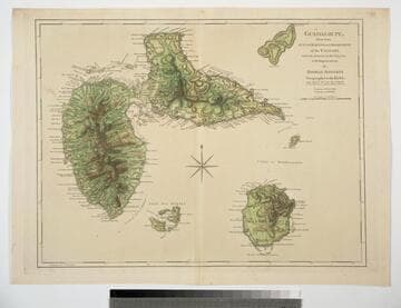
Guadaloupe, Done from Actual Surveys and Observations of the English, whilst the Island was in their possession with Improvements by Thomas Jefferys Geographer to the King
Visual Materials
See 093:772M for a later version of this map. Prime meridian: Ferro. Relief: hachures. Graphic Scale: Leagues. Projection: Cylindrical. Watermark: Crowned fleur-di-lis WF. Printing Process: Copper engraving. Verso Text: MS note: 771.
093:771
Image not available
North America from the French of Mr. d'Anville Improved with the English Surveys made since the Peace
Visual Materials
Kashnor notes, "Locates Chicago and gives a good map of the Illinois country and the country around the headwaters of the Mississippi, and the old forts and towns of the Ohio country." See 093:534M for an earlier version by Jefferys. RLIN record adds appeared in information. Prime meridian: London, Ferro. Relief: pictorial. Graphic Scale: Miles, leagues. Projection: Pseudocylindrical. Watermark: Crowned fleur-di-lis over GR. Printing Process: Copper engraving. References: McCorkle 755.2 (1775 state). Verso Text: MS note: 533.
093:533 M