Visual Materials
Course of the River Mississippi from the Balise to Fort Chartes; Taken on an Expedition to the Illinois, in the latter end of the year 1765. by Lieut. Ross of the 34th Regiment: Improved from those Surveys of the River made by the French
You might also be interested in
![Course of the River Mississipi.[sic] form the Balise to Fort Chartes taken on an Expedition to the Illinois, in the latter end of the Year 1765](/_next/image?url=https%3A%2F%2Frail.huntington.org%2FIIIF3%2FImage%2F22APN4KVMTFE%2Ffull%2F%5E360%2C%2F0%2Fdefault.jpg&w=750&q=75)
Course of the River Mississipi.[sic] form the Balise to Fort Chartes taken on an Expedition to the Illinois, in the latter end of the Year 1765
Visual Materials
Kashnor notes, " Locates the various Indian tribes and villages, and also the sites of forts and settlements destroyed by the Indians and French. Takes in the country around the old fort and village of Kaskaskia." The north end of this map ends just below Ste. Genevieve, the first French settlement in Missouri. Meridian of New Orleans marked.. Prime meridian: Ferro. Relief: pictorial. Graphic Scale: Miles, British, Leagues, Sea. Projection: Cylindrical. Watermark: Crowned fluer-di-lis. Printing Process: Copper engraving. Verso Text: MS note: 106.
105:106 M

Plan of Cape Fear River from the Bar to Brunswick
Visual Materials
Kashnor notes, "A rare chart issued for use during the American Revolution." Shows Fort Johnston and harbor. Gives sailing directions for entering Cape Fear River. Prime meridian: London. Relief: pictorial. Graphic Scale: Leagues, miles. Projection: Cylindrical. Watermark: Crowned fleur-di-lis. Printing Process: Copper engraving. Verso Text: MS note: 78.
093:078 M
![[Chart of Narraganset Bay from Newport to Providence]](/_next/image?url=https%3A%2F%2Frail.huntington.org%2FIIIF3%2FImage%2F22APN4KO5SV7%2Ffull%2F%5E360%2C%2F0%2Fdefault.jpg&w=750&q=75)
[Chart of Narraganset Bay from Newport to Providence]
Visual Materials
Kashnor notes, "A fine chart, issued during the American Revolution, giving a particularly good map of Rhode Island." Prime meridian: GM. Relief: pictorial & hachures. Graphic Scale: Miles, statute. Projection: Cylindrical. Watermark: Crowned fleur-di-lis. Printing Process: Copper engraving. Verso Text: MS note: 125.
093:125 M
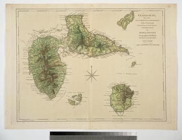
Guadaloupe, Done from Actual Surveys and Observations of the English, whilst the Island was in their possession with Improvements by Thomas Jefferys Geographer to the King
Visual Materials
See 093:772M for a later version of this map. Prime meridian: Ferro. Relief: hachures. Graphic Scale: Leagues. Projection: Cylindrical. Watermark: Crowned fleur-di-lis WF. Printing Process: Copper engraving. Verso Text: MS note: 771.
093:771

North America from the French of Mr. D'Anville improved with the English Surveys made Since the Peace
Visual Materials
Kashnor notes, "An interesting map, showing parts of Canada, with Newfoundland, and Nova Scotia, and the United States east of the Mississippi." Prime meridian: London, Ferro. Relief: pictorial. Graphic Scale: Miles, English, sea leagues. Projection: Pseudocylindrical. Watermark: Crowned fleur-di-lis W I. Printing Process: Copper engraving. Other Features: Cartouche. Verso Text: MS note: 114.
093:114 M

Chart of the Entrance to Hudson's River, from Sandy Hook to New York, with the Banks, Depths of Water, Sailing-marks, &ca
Visual Materials
Kashnor notes, "A scarce chart, issued during the early period of the American Revolution." Found in North-American pilot for New England, New York, Pensilvania (sic), Maryland, and Virginia 1777, per RLIN record. Relief: hachures. Graphic Scale: Miles, English. Projection: Plane. Watermark: Crowned fleur-di-lis. Printing Process: Copper engraving. References: Phillips 1209. Verso Text: MS note: 105.
093:105 M