Visual Materials
Guadaloupe, Done from Actual Surveys and Observations of the English, whilst the Island was in their possession with Improvements by Thomas Jefferys Geographer to the King

You might also be interested in

Martinico, Done from Actual Surveys and Observations, made by English Engineers whilst the Island was in their Possession, by Thomas Jefferys Geographer to the King
Visual Materials
Submap: Cul de Sac Royal. "VIII (upper right)" Prime meridian: Ferro. Relief: hachures. Graphic Scale: Leagues. Projection: Plane. Watermark: Crowned fleur-di-lis VI. Printing Process: Copper engraving. Other Features: Sub-maps. Verso Text: MS notes: 507 16.
105:507 M

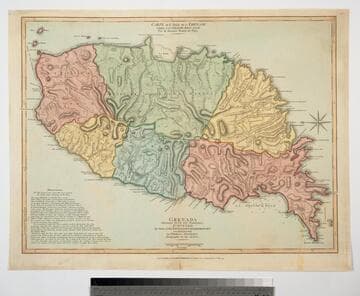
Grenada Divided into its Parishes, Surveyed By Order of His Excellency Governor Scott, and Engraved by Thomas Jefferys Geographer to the King
Visual Materials
Includes "Observations" on the island including "The Dotted Line along the Coast denotes the Fifty Paces belonging to the King." See 093:768 for a later copy. Prime meridian: London, Ferro. Relief: hachures. Graphic Scale: Feet, leagues. Projection: Cylindrical. Watermark: Crowned fleur-di-lis. Printing Process: Copper engraving. Verso Text: MS notes: 767 49.
093:767 M
Grenada Divided into its Parishes, Surveyed By Order of His Excellency Governor Scott, and Engraved by Thomas Jefferys Geographer to the King
Visual Materials
Includes "Observations" on the island including "The Dotted Line along the Coast denotes the Fifty Paces belonging to the King." See also 093:767M for an earlier copy. Prime meridian: London, Ferro. Relief: hachures. Graphic Scale: Feet, leagues. Projection: Cylindrical. Watermark: Crowned fleur-di-lis VI. Printing Process: Copper engraving. Verso Text: MS notes: 768.
093:768 M

Guadaloupe, Done from Actual Surveys and Observations of the English, whilst the Island was in their possession with material Improvements added since the Conquest of 1794 to those made by Thomas Jefferys Geographer to the King
Visual Materials
See 093:771M for an earlier varsion of this map. Prime meridian: Ferro. Relief: hachures. Graphic Scale: Leagues. Projection: Cylindrical. Printing Process: Copper engraving. Verso Text: MS note: 772.
093:772 M
Image not available
Island and Colony of Cayenne subject to the French, on the Continent of South America. By Thomas Jefferys, Geographer to his Royal Highness the Prince of Wales
Visual Materials
Cartouche: leaved. MS note: 660. Prime meridian: Ferro. Relief: hachures. Graphic Scale: Miles, leagues. Projection: Cylindrical. Watermark: Crowned fleur-di-lis voer LVG IV. Printing Process: Copper engraving. Other Features: Cartouche. Verso Text: MS notes: 660 57.
093:660 S

Map of the Isle of Cuba, with the Bahama Islands, Gulf of Florida, and Windward Passage: Drawn from English and Spanish Surveys. Engraved by Thomas Jefferys, Geographer to His Majesty
Visual Materials
Prime meridian: London, Ferro. Relief: pictorial. Graphic Scale: Miles, leagues. Projection: Cylindrical. Watermark: Fleur-di-lis on coat of arms. Printing Process: Copper engraving.
093:754 S