Visual Materials
Island and Colony of Cayenne subject to the French, on the Continent of South America. By Thomas Jefferys, Geographer to his Royal Highness the Prince of Wales
You might also be interested in
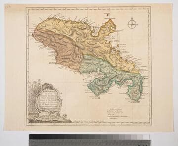
Martinico, one of the Caribbee Islands, in the West Indies; Subject to the French. according to Observations of Mr. Houel Engineer, by Thos. Jefferys, Geographer ti His Royal Highness the Prince
Visual Materials
Kashnor dates ca. 1760. Cartouche: framed with sugar cane. MS note: 813. Prime meridian: Ferro, London. Relief: hachures. Graphic Scale: Miles, leagues. Projection: Cylindrical. Watermark: Crowned fluer-di-lis over IVC. Printing Process: Copper engraving. Other Features: Cartouche. Verso Text: M
093:813 S

Island of Hispaniola called by the French St. Domingo. Subject to France & Spain. from the best Authorities by Thomas Jefferys, Geographer to His Majesty
Visual Materials
RLIN record shows Jefferys as "geographer to his Royal Highness the Prince of Wales." Prime meridian: London, Ferro. Relief: pictorial. Graphic Scale: Miles, leagues. Projection: Cylindrical. Watermark: Crowned fleur-di-lis JWhatman. Printing Process: Copper engraving. Verso Text: MS note: 418.
105:418 S

Authentic Plan of the Tolwn and Harbour of Cap-Francois in the Isle of St. Domingo. By Thomas Jefferys Geographer to His Royal Highness the Prince of Wales
Visual Materials
MS note: 779. Relief: hachures. Graphic Scale: Fathoms. Projection: Plane. Watermark: Crowned fleur-de-lis over LVG VI. Printing Process: Copper engraving.
093:779 M
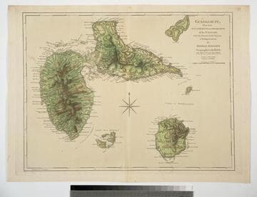
Guadaloupe, Done from Actual Surveys and Observations of the English, whilst the Island was in their possession with Improvements by Thomas Jefferys Geographer to the King
Visual Materials
See 093:772M for a later version of this map. Prime meridian: Ferro. Relief: hachures. Graphic Scale: Leagues. Projection: Cylindrical. Watermark: Crowned fleur-di-lis WF. Printing Process: Copper engraving. Verso Text: MS note: 771.
093:771
Image not available
Land-Kaart van het Eiland en de Volksplanting van Cayenne aan de Kust van Zuid-Amerika
Visual Materials
Kashnor dates as [Amsterdam ca. 1750]. This map may derive from Jeffery's 1760 maps, see 093:659 and 660. This map is made to the same scale as the Jeffery's map. Submap: Platte Grond van de Stad en 't Kasteel van Cayenne.. Prime meridian: Ferro. Relief: hachures. Graphic Scale: Leagues. Projection: Cylindrical. Watermark: Crowned fleur-di-lis VI. Printing Process: Copper engraving. Other Features: Sub-maps. Verso Text: MS note: 661.
093:661 S
Image not available
Map of Royal Island or Cape Breton Drawn by N. Bellin Engineer of the Marine
Visual Materials
Kashnor notes, "a rare map. probably engraved by Kitchin, and issued immediately after the taking of Louisburg by the Colonials." Kashnor dates [1746]. MS note: 150. Prime meridian: Paris. Relief: pictorial. Graphic Scale: Leagues. Projection: Cylindrical. Watermark: Crowned fleur-di-lis over LVG IV. Printing Process: Copper engraving. Verso Text: MS note: 596.
105:596 S