Visual Materials
Martinico, one of the Caribbee Islands, in the West Indies; Subject to the French. according to Observations of Mr. Houel Engineer, by Thos. Jefferys, Geographer ti His Royal Highness the Prince

You might also be interested in

Het Westindisch Eiland Martenique Volgens de nieuwste Waar nemmingen in Kaart gebragt. t Amsterdam by I. Tirion
Visual Materials
Kashnor dates as ca. 1750. Cartouche: framed w. sugan cane. MS note: No. 109. Prime meridian: Ferro. Relief: hachures. Graphic Scale: Leagues. Projection: Cylindrical. Watermark: Crowned fluer-du-lis VI. Printing Process: Copper engraving. Other Features: Cartouche. Verso Text: MS note: 816.
093:816 M
Image not available
Island and Colony of Cayenne subject to the French, on the Continent of South America. By Thomas Jefferys, Geographer to his Royal Highness the Prince of Wales
Visual Materials
Cartouche: leaved. MS note: 660. Prime meridian: Ferro. Relief: hachures. Graphic Scale: Miles, leagues. Projection: Cylindrical. Watermark: Crowned fleur-di-lis voer LVG IV. Printing Process: Copper engraving. Other Features: Cartouche. Verso Text: MS notes: 660 57.
093:660 S
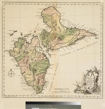
Guadaloupe one of the Caribbee Islands Subject to France in the West Indies, from the Best Authorities By T. Jefferys
Visual Materials
Kashnor dates as [1760]. RLIN record suggests 1768 and provides appeared in information. Cartouche: water falls & plants. Oversize binding spine still attached. Note: mile and league scales do not match.. Prime meridian: Ferro, London. Relief: pictorial & hachures. Graphic Scale: Miles, leagues. Projection: Cylindrical. Watermark: Crowned fleur-de-lis VI. Printing Process: Copper engraving. Other Features: Cartouche. Verso Text: MS notes: 93/775 148 La Guadaloupe La Guadalupe .
093:775 M

New Map of the Island of Tobago shewing all the Rocks Shoals and Soundings Engraved from an Actual Survey By Thos. Kitvhin, Hydrographer to His Majesty
Visual Materials
Kashnor dates as [1770]. Cartouche: neptune w. flowering bows.. Relief: no. Graphic Scale: Leagues. Projection: Cylindrical. Watermark: Crowned fluer-di-lis IV. Printing Process: Copper engraving. Other Features: Cartouche. Verso Text: MS notes: 838 50.
093:838 M

Martinico, Done from Actual Surveys and Observations, made by English Engineers whilst the Island was in their Possession, by Thomas Jefferys Geographer to the King
Visual Materials
Submap: Cul de Sac Royal. "VIII (upper right)" Prime meridian: Ferro. Relief: hachures. Graphic Scale: Leagues. Projection: Plane. Watermark: Crowned fleur-di-lis VI. Printing Process: Copper engraving. Other Features: Sub-maps. Verso Text: MS notes: 507 16.
105:507 M
Image not available
NeWand Accurate Map of the British Dominions in America, according to the Treaty of 1763; Divided into the Several Provinces and Jurisdictions. Projected upon the Best Authorities and Astronomical Observations, by Thos. Kitchin Geographer
Visual Materials
Kashnor notes, "Including Louisiana, North and South Carolina, Pennsylvania, Florida and NeWYork." Appeared in information from Rosenthal. Notes "Extensive MeadoWs full of Buffalos." See also 105-332. Prime meridian: London. Relief: pictorial. Graphic Scale: Miles, leagues. Projection: Pseudocylindrical. Watermark: CroWned fluer-di-lis. Printing Process: Copper engraving. Other Features: Cartouche. References: Sellers & Van Ee 104. Verso Text: MS note: 432.
093:432 M