Visual Materials
Het Westindisch Eiland Martenique Volgens de nieuwste Waar nemmingen in Kaart gebragt. t Amsterdam by I. Tirion

You might also be interested in
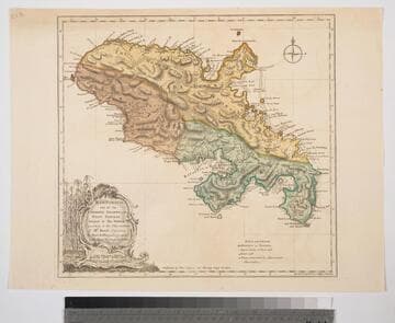
Martinico, one of the Caribbee Islands, in the West Indies; Subject to the French. according to Observations of Mr. Houel Engineer, by Thos. Jefferys, Geographer ti His Royal Highness the Prince
Visual Materials
Kashnor dates ca. 1760. Cartouche: framed with sugar cane. MS note: 813. Prime meridian: Ferro, London. Relief: hachures. Graphic Scale: Miles, leagues. Projection: Cylindrical. Watermark: Crowned fluer-di-lis over IVC. Printing Process: Copper engraving. Other Features: Cartouche. Verso Text: M
093:813 S

Algemeene Kaart van de Westindische Eilanden. te Amsterdam by Isaak Tirion
Visual Materials
Kashnor dates as ca. 1750. MS notes: No. 108 174. Prime meridian: Ferro. Relief: pictorial. Projection: Conic. Watermark: Crowned fleur-de-lis Van der Ley. Printing Process: Copper engraving. Verso Text: MS note: 705.
093:705 M
Image not available
Kaart van geheel Guajana of de Wilden-Ksut, en die der Spaansche Westindien, ep het Noord-end van Zuid-Amerika. Te Amsterdam by Is. Tirion
Visual Materials
Three submaps. Kashnor dates as ca. 1750. Submaps: Het Eiland Kurassau; Kaart van de Volkplanting aan Demerary en Rio D'Essequebo; De Haven en't Kasteel van Kurassau. (Curacao). Prime meridian: Ferro. Relief: pictorial. Graphic Scale: Leagues. Projection: Cylindrical. Watermark: Crowned fleur-di-lis VI. Printing Process: Copper engraving. Other Features: Sub-maps.
093:664 S
Image not available
Carte Générale de l'Amérique 1754
Visual Materials
Kashnor notes, "Indicates the coast of California to the Juan de Fuca Strait." Kashnor locates publication as Paris, author as Jean Palariest. MS note: 12 Jean Palariat. Prime meridian: Ferro. Relief: pictorial. Graphic Scale: Miles (naut), leagues. Projection: Pseudocylindrical. Watermark: Crowned fluer-di-lis IV. Printing Process: Copper engraving. Other Features: Cartouche. Verso Text: MS notes: 168 12.
093:168 M
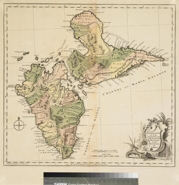
Guadaloupe one of the Caribbee Islands Subject to France in the West Indies, from the Best Authorities By T. Jefferys
Visual Materials
Kashnor dates as [1760]. RLIN record suggests 1768 and provides appeared in information. Cartouche: water falls & plants. Oversize binding spine still attached. Note: mile and league scales do not match.. Prime meridian: Ferro, London. Relief: pictorial & hachures. Graphic Scale: Miles, leagues. Projection: Cylindrical. Watermark: Crowned fleur-de-lis VI. Printing Process: Copper engraving. Other Features: Cartouche. Verso Text: MS notes: 93/775 148 La Guadaloupe La Guadalupe .
093:775 M
Image not available
Land-Kaart van het Eiland en de Volksplanting van Cayenne aan de Kust van Zuid-Amerika
Visual Materials
Kashnor dates as [Amsterdam ca. 1750]. This map may derive from Jeffery's 1760 maps, see 093:659 and 660. This map is made to the same scale as the Jeffery's map. Submap: Platte Grond van de Stad en 't Kasteel van Cayenne.. Prime meridian: Ferro. Relief: hachures. Graphic Scale: Leagues. Projection: Cylindrical. Watermark: Crowned fleur-di-lis VI. Printing Process: Copper engraving. Other Features: Sub-maps. Verso Text: MS note: 661.
093:661 S