Visual Materials
Kaart van geheel Guajana of de Wilden-Ksut, en die der Spaansche Westindien, ep het Noord-end van Zuid-Amerika. Te Amsterdam by Is. Tirion
You might also be interested in
Image not available
Land-Kaart van het Eiland en de Volksplanting van Cayenne aan de Kust van Zuid-Amerika
Visual Materials
Kashnor dates as [Amsterdam ca. 1750]. This map may derive from Jeffery's 1760 maps, see 093:659 and 660. This map is made to the same scale as the Jeffery's map. Submap: Platte Grond van de Stad en 't Kasteel van Cayenne.. Prime meridian: Ferro. Relief: hachures. Graphic Scale: Leagues. Projection: Cylindrical. Watermark: Crowned fleur-di-lis VI. Printing Process: Copper engraving. Other Features: Sub-maps. Verso Text: MS note: 661.
093:661 S

Algemeene Kaart van de Westindische Eilanden. te Amsterdam by Isaak Tirion
Visual Materials
Kashnor dates as ca. 1750. MS notes: No. 108 174. Prime meridian: Ferro. Relief: pictorial. Projection: Conic. Watermark: Crowned fleur-de-lis Van der Ley. Printing Process: Copper engraving. Verso Text: MS note: 705.
093:705 M

Het Westindisch Eiland Martenique Volgens de nieuwste Waar nemmingen in Kaart gebragt. t Amsterdam by I. Tirion
Visual Materials
Kashnor dates as ca. 1750. Cartouche: framed w. sugan cane. MS note: No. 109. Prime meridian: Ferro. Relief: hachures. Graphic Scale: Leagues. Projection: Cylindrical. Watermark: Crowned fluer-du-lis VI. Printing Process: Copper engraving. Other Features: Cartouche. Verso Text: MS note: 816.
093:816 M
Image not available
Kaart van de Landengte van Panama, Volgens de Spaanische aftekeninge opgemaakt
Visual Materials
Kashnor shows [Amsterdam, ca. 1745]. RLIN record lists Tirion as author, pub date as 1750. Relief: pictorial. Graphic Scale: Leagues. Projection: Plane. Watermark: Vander Ley Crowned fleur-di-lis. Printing Process: Copper engraving. Verso Text: MS note: 692.
093:692 S
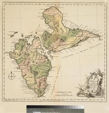
Guadaloupe one of the Caribbee Islands Subject to France in the West Indies, from the Best Authorities By T. Jefferys
Visual Materials
Kashnor dates as [1760]. RLIN record suggests 1768 and provides appeared in information. Cartouche: water falls & plants. Oversize binding spine still attached. Note: mile and league scales do not match.. Prime meridian: Ferro, London. Relief: pictorial & hachures. Graphic Scale: Miles, leagues. Projection: Cylindrical. Watermark: Crowned fleur-de-lis VI. Printing Process: Copper engraving. Other Features: Cartouche. Verso Text: MS notes: 93/775 148 La Guadaloupe La Guadalupe .
093:775 M
Image not available
Nieuwe Kaart van vde Grootbrittannische Volkplantingen in Noord America Waar in tevens de Fransche Bezittingen en de Landen, tusschen die beide Volken in geschil staande en de wederzydsche Pretensien duidelyk aangewesen worden. Getrokken uit de beste Kaarten van de Hr. Mitchell en anderen. Ter opheldering van de Hedendaagsche Historie van Groot Briottanie. Te Amsterdam by Isaak Tirion 1755
Visual Materials
Kashnor notes, "A rare map, issued during the Old French War. It is one of the earliest maps to locate Gwahago, the present-day Cleveland, and shows the boundaries claimed by Britain and France." MS note: H102 (upper right). Prime meridian: London. Relief: pictorial. Graphic Scale: Miles. Projection: Conic. Watermark: Crowned fleur-di-lis Van der Ley. Printing Process: Copper engraving. Verso Text: MS note: 531.
093:531 M