Visual Materials
New Map of the Island of Tobago shewing all the Rocks Shoals and Soundings Engraved from an Actual Survey By Thos. Kitvhin, Hydrographer to His Majesty

You might also be interested in
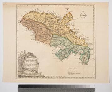
Martinico, one of the Caribbee Islands, in the West Indies; Subject to the French. according to Observations of Mr. Houel Engineer, by Thos. Jefferys, Geographer ti His Royal Highness the Prince
Visual Materials
Kashnor dates ca. 1760. Cartouche: framed with sugar cane. MS note: 813. Prime meridian: Ferro, London. Relief: hachures. Graphic Scale: Miles, leagues. Projection: Cylindrical. Watermark: Crowned fluer-di-lis over IVC. Printing Process: Copper engraving. Other Features: Cartouche. Verso Text: M
093:813 S

Tobago by Thomas Jefferys Geographer to His Majesty
Visual Materials
Kashnor notes, "A fine impression of the original issuer of this map." Submaps: Survey of Great & Little Courland Bays; Man of War Bay.. Prime meridian: London. Relief: no. Graphic Scale: Miles, leagues. Projection: Cylindrical. Watermark: Crowned fluer-di-lis over LVC IHYS over L. Ville dari. Printing Process: Copper engraving. Other Features: Sub-maps. Verso Text: MS note: 836.
093:836 M
Image not available
NeWand Accurate Map of the British Dominions in America, according to the Treaty of 1763; Divided into the Several Provinces and Jurisdictions. Projected upon the Best Authorities and Astronomical Observations, by Thos. Kitchin Geographer
Visual Materials
Kashnor notes, "Including Louisiana, North and South Carolina, Pennsylvania, Florida and NeWYork." Appeared in information from Rosenthal. Notes "Extensive MeadoWs full of Buffalos." See also 105-332. Prime meridian: London. Relief: pictorial. Graphic Scale: Miles, leagues. Projection: Pseudocylindrical. Watermark: CroWned fluer-di-lis. Printing Process: Copper engraving. Other Features: Cartouche. References: Sellers & Van Ee 104. Verso Text: MS note: 432.
093:432 M
Image not available
Carte Générale de l'Amérique 1754
Visual Materials
Kashnor notes, "Indicates the coast of California to the Juan de Fuca Strait." Kashnor locates publication as Paris, author as Jean Palariest. MS note: 12 Jean Palariat. Prime meridian: Ferro. Relief: pictorial. Graphic Scale: Miles (naut), leagues. Projection: Pseudocylindrical. Watermark: Crowned fluer-di-lis IV. Printing Process: Copper engraving. Other Features: Cartouche. Verso Text: MS notes: 168 12.
093:168 M

Het Westindisch Eiland Martenique Volgens de nieuwste Waar nemmingen in Kaart gebragt. t Amsterdam by I. Tirion
Visual Materials
Kashnor dates as ca. 1750. Cartouche: framed w. sugan cane. MS note: No. 109. Prime meridian: Ferro. Relief: hachures. Graphic Scale: Leagues. Projection: Cylindrical. Watermark: Crowned fluer-du-lis VI. Printing Process: Copper engraving. Other Features: Cartouche. Verso Text: MS note: 816.
093:816 M

General Map of the Southern British Colonies in America. Comprehending North and South Carolina, Georgia, East and West Florida, with the Neighboring Indian Countries. From the Modern Surveys of Engineer de Brahm, Capt. Collet, Mouzon & Others and from the Large Hydrographical Survey of the Coasts of East and West Florida. By B. Romans, 1776
Visual Materials
Kashnor notes, "A valuable map, showing the main roads, issued during the early part of the American Revolution." Framed cartouche, submaps of Charlestown (sic) and St. Augustine.. Prime meridian: London. Relief: pictorial. Graphic Scale: Miles, leagues. Projection: Pseudocylindrical. Watermark: Crowned fleur-di-lis. Printing Process: Copper engraving. Other Features: Sub-mapsCartouche. Verso Text: MS note: 70.
093:070 M