Visual Materials
Tobago by Thomas Jefferys Geographer to His Majesty

You might also be interested in

New Map of the Island of Tobago shewing all the Rocks Shoals and Soundings Engraved from an Actual Survey By Thos. Kitvhin, Hydrographer to His Majesty
Visual Materials
Kashnor dates as [1770]. Cartouche: neptune w. flowering bows.. Relief: no. Graphic Scale: Leagues. Projection: Cylindrical. Watermark: Crowned fluer-di-lis IV. Printing Process: Copper engraving. Other Features: Cartouche. Verso Text: MS notes: 838 50.
093:838 M

Coast of West Florida and Louisiana by Thos. Jefferys, Geographer to His Majesty.: Peninsula and Gulf of Florida or Channel of Bahama with Bahama Islands, by Thos. Jefferys, Geographer to His Masjesty
Visual Materials
Two maps spliced to form one map. See 105:392 for an earlier version. Prime meridian: London. Relief: pictorial. Projection: Cylindrical. Watermark: Crowned fluer-di-lis VI. Printing Process: Copper engraving. Verso Text: MS notes: 740 25.
093:740 M

The Coast of West Florida and Louisiana by Thos. Jefferys, Geographer to His Majesty.: Peninsula and Gulf of Florida or Channel of Bahama with Bahama Islands, by Thos. Jefferys, Geographer to His Majesty
Visual Materials
Two maps spliced to form one map. See 105:393 for a later version of this map. Prime meridian: London. Relief: pictorial. Projection: Cylindrical. Watermark: Crowned fluer-di-lis VI. Printing Process: Copper engraving. Verso Text: MS notes: 392 32.
105:392 M
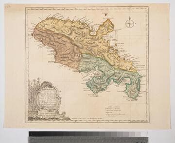
Martinico, one of the Caribbee Islands, in the West Indies; Subject to the French. according to Observations of Mr. Houel Engineer, by Thos. Jefferys, Geographer ti His Royal Highness the Prince
Visual Materials
Kashnor dates ca. 1760. Cartouche: framed with sugar cane. MS note: 813. Prime meridian: Ferro, London. Relief: hachures. Graphic Scale: Miles, leagues. Projection: Cylindrical. Watermark: Crowned fluer-di-lis over IVC. Printing Process: Copper engraving. Other Features: Cartouche. Verso Text: M
093:813 S
Image not available
Map of North America and The West Indies by L. S. de la Rochette
Visual Materials
Kashnor notes, "One of the last maps issued showing the Illinois, Ohio, Michigan and Wisconsin country as part of Canada and the old colonies." Submap: Supplement for Hudsons and Baffins Bays.. Prime meridian: London, Ferro. Relief: pictorial & hachures. Graphic Scale: Miles, leagues. Projection: Pseudocylindrical. Watermark: Crowned fleur-di-lis over LVC. Printing Process: Copper engraving. Other Features: Sub-maps. Verso Text: MS notes: West Indies 14 13 12 North America 10 11 520.
093:520 M

The Coast of West Florida and Louisiana by Thos. Jefferys, Geographer to His Majesty.: Peninsula and Gulf of Florida or Channel of Bahama with Bahama Islands, by Thos. Jefferys, Geographer to His Masjesty
Visual Materials
Two maps spliced to form one map. See 105:392 for a later version. See 105:393-Dup. for another copy. Prime meridian: London. Relief: pictorial. Projection: Cylindrical. Watermark: Crowned fluer-di-lis VI. Printing Process: Copper engraving. Verso Text: MS notes: 393.
105:393 M