Visual Materials
Coast of West Florida and Louisiana by Thos. Jefferys, Geographer to His Majesty.: Peninsula and Gulf of Florida or Channel of Bahama with Bahama Islands, by Thos. Jefferys, Geographer to His Masjesty

You might also be interested in

The Coast of West Florida and Louisiana by Thos. Jefferys, Geographer to His Majesty.: Peninsula and Gulf of Florida or Channel of Bahama with Bahama Islands, by Thos. Jefferys, Geographer to His Masjesty
Visual Materials
Two maps spliced to form one map. See 105:392 for a later version. See 105:393-Dup. for another copy. Prime meridian: London. Relief: pictorial. Projection: Cylindrical. Watermark: Crowned fluer-di-lis VI. Printing Process: Copper engraving. Verso Text: MS notes: 393.
105:393 M

The Coast of West Florida and Louisiana by Thos. Jefferys, Geographer to His Majesty.: Peninsula and Gulf of Florida or Channel of Bahama with Bahama Islands, by Thos. Jefferys, Geographer to His Majesty
Visual Materials
Two maps spliced to form one map. See 105:393 for a later version of this map. Prime meridian: London. Relief: pictorial. Projection: Cylindrical. Watermark: Crowned fluer-di-lis VI. Printing Process: Copper engraving. Verso Text: MS notes: 392 32.
105:392 M

Tobago by Thomas Jefferys Geographer to His Majesty
Visual Materials
Kashnor notes, "A fine impression of the original issuer of this map." Submaps: Survey of Great & Little Courland Bays; Man of War Bay.. Prime meridian: London. Relief: no. Graphic Scale: Miles, leagues. Projection: Cylindrical. Watermark: Crowned fluer-di-lis over LVC IHYS over L. Ville dari. Printing Process: Copper engraving. Other Features: Sub-maps. Verso Text: MS note: 836.
093:836 M
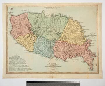
Grenada Divided into its Parishes, Surveyed By Order of His Excellency Governor Scott, and Engraved by Thomas Jefferys Geographer to the King
Visual Materials
Includes "Observations" on the island including "The Dotted Line along the Coast denotes the Fifty Paces belonging to the King." See also 093:767M for an earlier copy. Prime meridian: London, Ferro. Relief: hachures. Graphic Scale: Feet, leagues. Projection: Cylindrical. Watermark: Crowned fleur-di-lis VI. Printing Process: Copper engraving. Verso Text: MS notes: 768.
093:768 M

Island of Cuba with part of the Bahama Banks & the Martyrs. By Thos. Jeffereys, Geographer to his Majesty
Visual Materials
Kashnor notes, "Includes an accurate map of the adjacent seas, with soundings." Prime meridian: London, Ferro. Relief: pictorial. Projection: Mercator. Watermark: Crowned fleur-di-lis VI. Printing Process: Copper engraving. Verso Text: MS notes: 378 Island of Cuba & Bahama Banks.
105:378 M
Image not available
Bay of Honduras, By Thos. Jefferys Geographer to His Majesty
Visual Materials
"BF 10. (upper right)" Prime meridian: London. Relief: pictorial. Projection: Cylindrical. Watermark: Crowned fleur-di-lis WF. Printing Process: Copper engraving. Verso Text: MS notes: 892 27.
105:892 M