Visual Materials
Authentic Plan of the Tolwn and Harbour of Cap-Francois in the Isle of St. Domingo. By Thomas Jefferys Geographer to His Royal Highness the Prince of Wales

You might also be interested in
Image not available
Island and Colony of Cayenne subject to the French, on the Continent of South America. By Thomas Jefferys, Geographer to his Royal Highness the Prince of Wales
Visual Materials
Cartouche: leaved. MS note: 660. Prime meridian: Ferro. Relief: hachures. Graphic Scale: Miles, leagues. Projection: Cylindrical. Watermark: Crowned fleur-di-lis voer LVG IV. Printing Process: Copper engraving. Other Features: Cartouche. Verso Text: MS notes: 660 57.
093:660 S

Martinico, Done from Actual Surveys and Observations, made by English Engineers whilst the Island was in their Possession, by Thomas Jefferys Geographer to the King
Visual Materials
Submap: Cul de Sac Royal. "VIII (upper right)" Prime meridian: Ferro. Relief: hachures. Graphic Scale: Leagues. Projection: Plane. Watermark: Crowned fleur-di-lis VI. Printing Process: Copper engraving. Other Features: Sub-maps. Verso Text: MS notes: 507 16.
105:507 M
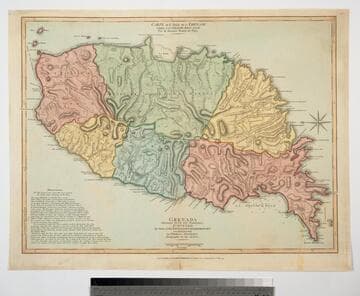
Grenada Divided into its Parishes, Surveyed By Order of His Excellency Governor Scott, and Engraved by Thomas Jefferys Geographer to the King
Visual Materials
Includes "Observations" on the island including "The Dotted Line along the Coast denotes the Fifty Paces belonging to the King." See also 093:767M for an earlier copy. Prime meridian: London, Ferro. Relief: hachures. Graphic Scale: Feet, leagues. Projection: Cylindrical. Watermark: Crowned fleur-di-lis VI. Printing Process: Copper engraving. Verso Text: MS notes: 768.
093:768 M
Image not available
New Map of Nova Scotia, and Cape Breton Island with the adjacent parts of New England and Canada, Composed from a great number of actual Surveys; and other material Regulated by many new Astronomical Observations of the Longitude as well as Latitude; by Thomas Jefferys, Geographer to the King
Visual Materials
See map 093:269M for earlier edition. Note border change. Prime meridian: Ferro. Relief: pictorial. Projection: Conic. Watermark: Crowned fleur-di-lis VI. Printing Process: Copper engraving. Other Features: Cartouche. Verso Text: MS note: 270 34.
093:270 M

Plan of the Town and Citadel of Fort Royal the Capital of Martinico. with the Bay of Cul de Sac Royal. By Mr. de Caylus, Engineer-General of the French Islands
Visual Materials
Submap: Port of Carenage. MS note :819. Relief: hachures. Projection: Plane. Watermark: Crowned fluer-di-lis VI. Printing Process: Copper engraving. Other Features: Sub-maps. Verso Text: Ms note: 819.
093:819 S
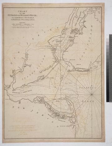
Chart of the Entrance of Hudson's River, from Sandy Hook to New York, with the Banks, Depths of Water, Sailing-marks &ca
Visual Materials
Kashnor notes, " The first issue of this chart. It was reissued in 1800 by Laurie & Whittle, but without date." Relief: hachures. Graphic Scale: Miles. Projection: Plane. Watermark: Crowned fleur-di-lis VI. Printing Process: Copper engraving. Verso Text: MS notes: 3 578.
105:578 M