Visual Materials
Plan of the Town and Citadel of Fort Royal the Capital of Martinico. with the Bay of Cul de Sac Royal. By Mr. de Caylus, Engineer-General of the French Islands

You might also be interested in
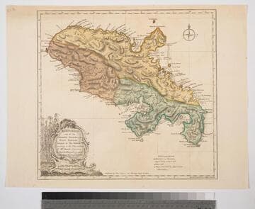
Martinico, one of the Caribbee Islands, in the West Indies; Subject to the French. according to Observations of Mr. Houel Engineer, by Thos. Jefferys, Geographer ti His Royal Highness the Prince
Visual Materials
Kashnor dates ca. 1760. Cartouche: framed with sugar cane. MS note: 813. Prime meridian: Ferro, London. Relief: hachures. Graphic Scale: Miles, leagues. Projection: Cylindrical. Watermark: Crowned fluer-di-lis over IVC. Printing Process: Copper engraving. Other Features: Cartouche. Verso Text: M
093:813 S

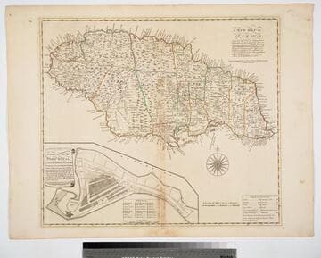
Accurate Map of North and South Carolina with their Indian Frontiers, showing in a distinct manner all the Mountains, Rivers, Swamps, Marshes, Bays, Creeks, Harbours, Sandbanks and Soundings on the Coast, with the Roads and Indian Paths as well as the Boundary or Provincial Lines, the Several Townships and other divisions of the Land in Both the Provinces; the whole from Actual Surveys by Henry Mouzon and others
Visual Materials
Noted as duplicate of 192531, 29-30 and 2813, #73-74. Submap: Harbour at Port Royal; Bar and Harbour of Charlestown.. Prime meridian: London. Relief: hachures. Projection: Cylindrical. Watermark: Crowned fluer-di-lis VI. Printing Process: Copper engraving. Other Features: Sub-maps. Verso Text: MS note: 73 H. E. H. Dupl. stamp..
105:073 M

Martinico, Done from Actual Surveys and Observations, made by English Engineers whilst the Island was in their Possession, by Thomas Jefferys Geographer to the King
Visual Materials
Submap: Cul de Sac Royal. "VIII (upper right)" Prime meridian: Ferro. Relief: hachures. Graphic Scale: Leagues. Projection: Plane. Watermark: Crowned fleur-di-lis VI. Printing Process: Copper engraving. Other Features: Sub-maps. Verso Text: MS notes: 507 16.
105:507 M
Image not available
Land-Kaart van het Eiland en de Volksplanting van Cayenne aan de Kust van Zuid-Amerika
Visual Materials
Kashnor dates as [Amsterdam ca. 1750]. This map may derive from Jeffery's 1760 maps, see 093:659 and 660. This map is made to the same scale as the Jeffery's map. Submap: Platte Grond van de Stad en 't Kasteel van Cayenne.. Prime meridian: Ferro. Relief: hachures. Graphic Scale: Leagues. Projection: Cylindrical. Watermark: Crowned fleur-di-lis VI. Printing Process: Copper engraving. Other Features: Sub-maps. Verso Text: MS note: 661.
093:661 S

Coast of West Florida and Louisiana by Thos. Jefferys, Geographer to His Majesty.: Peninsula and Gulf of Florida or Channel of Bahama with Bahama Islands, by Thos. Jefferys, Geographer to His Masjesty
Visual Materials
Two maps spliced to form one map. See 105:392 for an earlier version. Prime meridian: London. Relief: pictorial. Projection: Cylindrical. Watermark: Crowned fluer-di-lis VI. Printing Process: Copper engraving. Verso Text: MS notes: 740 25.
093:740 M
New Map of Jamaica In which the Several Towns Forts & Settlements are Accurately laid down, as well as the situations & depths of the most noted Harbours and Anchoring Places, with the limits and boundaries of the different Parishes, as they have been regulated by Law, or settled by Custom, the greatest part Drawn or Corrected from actual Surveys Made by Mr. Sheffield and others
Visual Materials
Submap: General Plan of Port Royal in which Different States of the Town are Accurately laid Down. . Prime meridian: London. Relief: pictorial. Graphic Scale: Miles. Projection: Cylindrical. Watermark: Crowned fleur-di-lis IV. Printing Process: Copper engraving. Other Features: Sub-maps. Verso Text: MS notes: 801 J5..
093:801 M