Visual Materials
Island of Hispaniola called by the French St. Domingo. Subject to France & Spain. from the best Authorities by Thomas Jefferys, Geographer to His Majesty

You might also be interested in
Image not available
Island and Colony of Cayenne subject to the French, on the Continent of South America. By Thomas Jefferys, Geographer to his Royal Highness the Prince of Wales
Visual Materials
Cartouche: leaved. MS note: 660. Prime meridian: Ferro. Relief: hachures. Graphic Scale: Miles, leagues. Projection: Cylindrical. Watermark: Crowned fleur-di-lis voer LVG IV. Printing Process: Copper engraving. Other Features: Cartouche. Verso Text: MS notes: 660 57.
093:660 S

Martinico, Done from Actual Surveys and Observations, made by English Engineers whilst the Island was in their Possession, by Thomas Jefferys Geographer to the King
Visual Materials
Submap: Cul de Sac Royal. "VIII (upper right)" Prime meridian: Ferro. Relief: hachures. Graphic Scale: Leagues. Projection: Plane. Watermark: Crowned fleur-di-lis VI. Printing Process: Copper engraving. Other Features: Sub-maps. Verso Text: MS notes: 507 16.
105:507 M
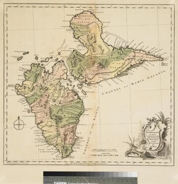
Guadaloupe one of the Caribbee Islands Subject to France in the West Indies, from the Best Authorities By T. Jefferys
Visual Materials
Kashnor dates as [1760]. RLIN record suggests 1768 and provides appeared in information. Cartouche: water falls & plants. Oversize binding spine still attached. Note: mile and league scales do not match.. Prime meridian: Ferro, London. Relief: pictorial & hachures. Graphic Scale: Miles, leagues. Projection: Cylindrical. Watermark: Crowned fleur-de-lis VI. Printing Process: Copper engraving. Other Features: Cartouche. Verso Text: MS notes: 93/775 148 La Guadaloupe La Guadalupe .
093:775 M

Map of the Isle of Cuba, with the Bahama Islands, Gulf of Florida, and Windward Passage: Drawn from English and Spanish Surveys. Engraved by Thomas Jefferys, Geographer to His Majesty
Visual Materials
Prime meridian: London, Ferro. Relief: pictorial. Graphic Scale: Miles, leagues. Projection: Cylindrical. Watermark: Fleur-di-lis on coat of arms. Printing Process: Copper engraving.
093:754 S
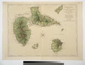
Guadaloupe, Done from Actual Surveys and Observations of the English, whilst the Island was in their possession with Improvements by Thomas Jefferys Geographer to the King
Visual Materials
See 093:772M for a later version of this map. Prime meridian: Ferro. Relief: hachures. Graphic Scale: Leagues. Projection: Cylindrical. Watermark: Crowned fleur-di-lis WF. Printing Process: Copper engraving. Verso Text: MS note: 771.
093:771
Image not available
New Map of Nova Scotia, and Cape Breton Island with the adjacent parts of New England and Canada, Composed from a great number of actual Surveys; and other material Regulated by many new Astronomical Observations of the Longitude as well as Latitude; by Thomas Jefferys, Geographer to the King
Visual Materials
See map 093:270M for later edition. RLIN record provides appeared in information. Kershaw identifies this as the fourth state of Jefferys' map. Prime meridian: Ferro. Relief: pictorial. Projection: Conic. Watermark: Crowned fleur-di-lis VI. Printing Process: Copper engraving. Other Features: Cartouche. References: Kershaw 745; LC Phillips 1166,1208. Verso Text: MS note: 269.
093:269 M