Visual Materials
Map of the Isle of Cuba, with the Bahama Islands, Gulf of Florida, and Windward Passage: Drawn from English and Spanish Surveys. Engraved by Thomas Jefferys, Geographer to His Majesty

You might also be interested in

A Map of the Isle of Cuba, with the Bahama Islands, Gulf of Florida, and Windward Passage : Drawn from English and Spanish Surveys / Engraved by Thomas Jefferys, Geographer to His Majesty
Rare Books
Probably removed from Jeffreys' "A general topography of North America and the West Indies." (See Library of Congress G1105 .J4 1768, book is fully digitized online.) Prime meridian: London, Ferro. Relief: pictorial. Graphic Scale: Miles, Leagues. Projection: Cylindrical. Printing Process: Copper engraving.
295804
Image not available
Island and Colony of Cayenne subject to the French, on the Continent of South America. By Thomas Jefferys, Geographer to his Royal Highness the Prince of Wales
Visual Materials
Cartouche: leaved. MS note: 660. Prime meridian: Ferro. Relief: hachures. Graphic Scale: Miles, leagues. Projection: Cylindrical. Watermark: Crowned fleur-di-lis voer LVG IV. Printing Process: Copper engraving. Other Features: Cartouche. Verso Text: MS notes: 660 57.
093:660 S

Island of Hispaniola called by the French St. Domingo. Subject to France & Spain. from the best Authorities by Thomas Jefferys, Geographer to His Majesty
Visual Materials
RLIN record shows Jefferys as "geographer to his Royal Highness the Prince of Wales." Prime meridian: London, Ferro. Relief: pictorial. Graphic Scale: Miles, leagues. Projection: Cylindrical. Watermark: Crowned fleur-di-lis JWhatman. Printing Process: Copper engraving. Verso Text: MS note: 418.
105:418 S

Coast of West Florida and Louisiana by Thos. Jefferys, Geographer to His Majesty.: Peninsula and Gulf of Florida or Channel of Bahama with Bahama Islands, by Thos. Jefferys, Geographer to His Masjesty
Visual Materials
Two maps spliced to form one map. See 105:392 for an earlier version. Prime meridian: London. Relief: pictorial. Projection: Cylindrical. Watermark: Crowned fluer-di-lis VI. Printing Process: Copper engraving. Verso Text: MS notes: 740 25.
093:740 M
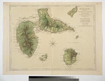
Guadaloupe, Done from Actual Surveys and Observations of the English, whilst the Island was in their possession with Improvements by Thomas Jefferys Geographer to the King
Visual Materials
See 093:772M for a later version of this map. Prime meridian: Ferro. Relief: hachures. Graphic Scale: Leagues. Projection: Cylindrical. Watermark: Crowned fleur-di-lis WF. Printing Process: Copper engraving. Verso Text: MS note: 771.
093:771

The Coast of West Florida and Louisiana by Thos. Jefferys, Geographer to His Majesty.: Peninsula and Gulf of Florida or Channel of Bahama with Bahama Islands, by Thos. Jefferys, Geographer to His Majesty
Visual Materials
Two maps spliced to form one map. See 105:393 for a later version of this map. Prime meridian: London. Relief: pictorial. Projection: Cylindrical. Watermark: Crowned fluer-di-lis VI. Printing Process: Copper engraving. Verso Text: MS notes: 392 32.
105:392 M