Visual Materials
Plan of the Operations of the King's Army under the Command of General Sr. William HoWe, K.B. in NeW York and East NeW Jersey, against the American Forces Commanded by General Washington, From the 12th. of October, to the 28th. of November 1776

You might also be interested in
Image not available
An Exact Plan of Charleston Bar and Harbour. From an Actual Survey. With the attack of Fort Sulivan, on the 28th of June 1776. by His Majesty's Squadron. Commanded by Sir Peter Parker
Visual Materials
Kashnor notes, "Indicates the vessels engaged, giving partuculars of their guns, commanders, and casualties. A very fine plan." Relief: no. Graphic Scale: Miles. Projection: Plane. Watermark: Crowned fleur-di-lis VI. Printing Process: Copper engraving. Verso Text: 8 MS note: 319.
105:319 M

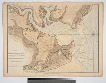
Plan of the Attack on Fort Sulivan, near Charles Town in South Carolina, by a Squadron of His Majesty's Ships, on the 28th of June 1776, with the Disposition of the King's Land Forces, and the Encampments and Entrenchments of the Rebels
Visual Materials
Kashnor notes, "scarce plan." See 093:081M for duplicate copy (with subtext). Inset map showing: Plan of the Platform in Sulivans Fort, by Lt. Colonel Thos. James of the Rl. Rt. of Artillery. MS note: 011 27 ke. Relief: hachures. Graphic Scale: Miles. Projection: Plane. Watermark: Crowned fleur-di-lis. Printing Process: Copper engraving. Other Features: Sub-maps. Verso Text: MS notes: Cat. #105 #80.
105:080 S
Plan of the Town, Bar, Harbour and Environs, of Charlestown in South Carolina, with all the Channels, Soundings, Sailing-marks &c. From the Surveys made in the Colony Engraved by William Faden, Charing Cross, 1780
Visual Materials
Kashnor notes, "A very scarce plan issued for use during the American Revolution." Atlas reference from The American Revolution 1775-1783, Naval History Division, Department of the Navy, Washington, 1972. Huntington f G1202 S3U5. Compass Rose. Relief: hachures. Graphic Scale: Miles. Projection: Cylindrical. Watermark: Crowned fleur-di-lis. Printing Process: Copper engraving.
093:082 M
Image not available
A Chart of the Bay and Harbour of Pensacola, in the Province of West Florida, Surveyed by George Gould, A.M. Published by Command of Government by J. F. W. Des Barres Esqr
Visual Materials
Kashnor notes, "Exceedingly rare, and one of the most rare of Des Barres war charts. Only a few other copies appear to be known, and there is no record of a coloured impression." MS note: 75. Prime meridian: GM. Relief: hachures. Graphic Scale: Miles. Projection: Plane. Watermark: Crowned fleur-di-lis over JVC VI. Printing Process: Copper engraving. Verso Text: MS note:990.
105:990 M
Image not available
Quebek De Hoofstad van Kanada; aan de Rivier van St.Laurens: door de Engelschen belegero en by Verdrag bemagtigd, in't jaar 1759
Visual Materials
Kashnor notes, " A rare Dutch plan of the fall of Quebec." Submap of St. Lawrence River. Another copy of Jefferys map, see 093:328, etc. Kashnor dates as circa 1760. Submap: De Rivier boven Quebek.. Relief: hachures. Graphic Scale: Miles. Projection: Plane. Watermark: Crowned fleur-di-lis Van Der Ley. Printing Process: Copper engraving. Other Features: CartoucheSub-maps. Verso Text: MS note: 330.
093:330 M
Image not available
Map of the most Inhabited part of Virginia, containing the whole Province of Maryland, with Part of Pensilvania, New Jersey and North Carolina, Drawn by Joshua Fry and Peter Jefferson in 1775
Visual Materials
Kashnor dates printing as [1776]. Cartouche: Traders shipping tobacco. Table: Road distances from Williamburg and other Virginia points as recorded by J. Dalrymple in 1755.. Prime meridian: Philadelphia, Curratuck Inlet. Relief: pictorial. Graphic Scale: Miles. Projection: Cylindrical. Watermark: Crowned fleur-di-lis over GR. Printing Process: Copper engraving. Other Features: Cartouche. Verso Text: MS notes: 589 25 26.
093:589 M