Visual Materials
An Exact Plan of Charleston Bar and Harbour. From an Actual Survey. With the attack of Fort Sulivan, on the 28th of June 1776. by His Majesty's Squadron. Commanded by Sir Peter Parker
You might also be interested in
Image not available
An Exact Plan of Charles-town-Bar and Harbour : From an actual survey ; With the attack of Fort Sulivan, on the 28th of June 1776, By His Majesty's Squadron, Commanded by Sir Peter Parker
Rare Books
Prime meridian: GM. Relief: no. Graphic Scale: Miles. Projection: Cylindrical. Watermark: Crowned shield VI. Printing Process: Copper engraving.
295805

Plan of the Attack on Fort Sulivan, near Charles Town in South Carolina, by a Squadron of His Majesty's Ships, on the 28th of June 1776, with the Disposition of the King's Land Forces, and the Encampments and Entrenchments of the Rebels
Visual Materials
Kashnor notes, "scarce plan." See 093:081M for duplicate copy (with subtext). Inset map showing: Plan of the Platform in Sulivans Fort, by Lt. Colonel Thos. James of the Rl. Rt. of Artillery. MS note: 011 27 ke. Relief: hachures. Graphic Scale: Miles. Projection: Plane. Watermark: Crowned fleur-di-lis. Printing Process: Copper engraving. Other Features: Sub-maps. Verso Text: MS notes: Cat. #105 #80.
105:080 S

New Map of the West Indian Islands, as they are Possessed by the European Powers
Visual Materials
Kashnor ontes, "Indicates the English, Dutch, French, and Spanish possessions." Cartouche: branches.. "Drawn from the most Recent Authorities." Prime meridian: London. Relief: pictorial. Graphic Scale: Leagues. Projection: Cylindrical. Watermark: Crowned fleur-di-lis VI. Printing Process: Copper engraving. Other Features: Cartouche. Verso Text: MS note: 966.
105:966 M

Martinico, Done from Actual Surveys and Observations, made by English Engineers whilst the Island was in their Possession, by Thomas Jefferys Geographer to the King
Visual Materials
Submap: Cul de Sac Royal. "VIII (upper right)" Prime meridian: Ferro. Relief: hachures. Graphic Scale: Leagues. Projection: Plane. Watermark: Crowned fleur-di-lis VI. Printing Process: Copper engraving. Other Features: Sub-maps. Verso Text: MS notes: 507 16.
105:507 M
Image not available
A Plan of Cape Fear River from the Bar to Brunswick
Visual Materials
Kashnor notes, "A very scarce chart. It was reissued in 1800 by Laurie & Whittle." MS note: c 38. Prime meridian: London. Relief: no. Graphic Scale: Miles. Projection: Plane. Watermark: Crowned fleur-di-lis VI. Printing Process: Copper engraving. Verso Text: MS notes: 347 7.
105:347 M
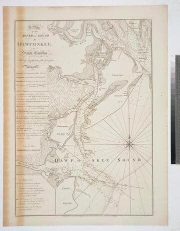
A Plan of the River and Sound of D'Awfoskee, in South Carolina. Survey'd by Captain John Gascoigne
Visual Materials
MS note: c 36. Prime meridian: London. Relief: no. Graphic Scale: Miles. Projection: Plane. Watermark: Crowned fleur-di-lis VI. Printing Process: Copper engraving. Verso Text: MS note: 349 10.
105:349 M