Visual Materials
New Map of the West Indian Islands, as they are Possessed by the European Powers

You might also be interested in
Image not available
A Map of South America With all the European Settlements & whatever else is remarkable from the latest & best Observations
Visual Materials
Kashnor dates as ca. 1770. RLIN record indicates this may be as early as 1745. Cartouche: frilled. Stain upper right from material stuck to verso.. Prime meridian: London. Relief: pictorial. Projection: Azimuthal. Watermark: Crowned fleur-di-lis VI. Printing Process: Copper engraving. Other Features: Cartouche. Verso Text: MS note: 849.
105:849 S

Martinico, Done from Actual Surveys and Observations, made by English Engineers whilst the Island was in their Possession, by Thomas Jefferys Geographer to the King
Visual Materials
Submap: Cul de Sac Royal. "VIII (upper right)" Prime meridian: Ferro. Relief: hachures. Graphic Scale: Leagues. Projection: Plane. Watermark: Crowned fleur-di-lis VI. Printing Process: Copper engraving. Other Features: Sub-maps. Verso Text: MS notes: 507 16.
105:507 M
Image not available
A New and Correct Map of the Province of Quebec with the Adjacent States and Provinces, from the French Surveys, Connected with those made by Captain Carver, and other Officers, in His Majesty's Service
Visual Materials
Three inset maps. Wilderness cartouche. Submaps: Particular Survey of the Isles of Montreal; City of Quebec; Course of the River St. Laurence from la Valterie to Quebec on a Larger Scale.. Prime meridian: London. Relief: pictorial. Graphic Scale: Miles, Leagues. Projection: Pseudocylindrical. Watermark: Crowned fleur-di-lis, VI. Printing Process: Copper engraving. Other Features: CartoucheSub-maps. Verso Text: MS note: 760.
105:760 M
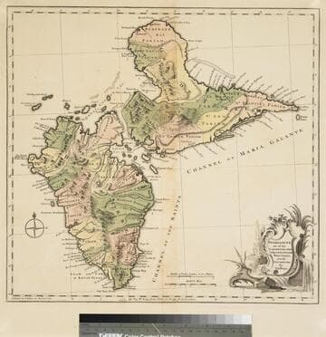
Guadaloupe one of the Caribbee Islands Subject to France in the West Indies, from the Best Authorities By T. Jefferys
Visual Materials
Kashnor dates as [1760]. RLIN record suggests 1768 and provides appeared in information. Cartouche: water falls & plants. Oversize binding spine still attached. Note: mile and league scales do not match.. Prime meridian: Ferro, London. Relief: pictorial & hachures. Graphic Scale: Miles, leagues. Projection: Cylindrical. Watermark: Crowned fleur-de-lis VI. Printing Process: Copper engraving. Other Features: Cartouche. Verso Text: MS notes: 93/775 148 La Guadaloupe La Guadalupe .
093:775 M
Image not available
New Map of Nova Scotia, and Cape Breton Island with the adjacent parts of New England and Canada, Composed from a great number of actual Surveys; and other material Regulated by many new Astronomical Observations of the Longitude as well as Latitude; by Thomas Jefferys, Geographer to the King
Visual Materials
See map 093:269M for earlier edition. Note border change. Prime meridian: Ferro. Relief: pictorial. Projection: Conic. Watermark: Crowned fleur-di-lis VI. Printing Process: Copper engraving. Other Features: Cartouche. Verso Text: MS note: 270 34.
093:270 M
Image not available
Asia Corrected from the Observations communicated to the Royal Society at London and the Royal Academy at Paris
Visual Materials
Kashnor notes, "Includes Manila and the Philippine Islands." Kashnor dates as ca. 1720. Cartouche: Figures of Gods, humans & animals.. "By John Senex and Jon. Maxwell. At the Globe in Salisbury Court near Fleet Street in London." "H. Hulsbergh Scul. (cartouche)" Prime meridian: London. Relief: pictorial. Graphic Scale: Leagues, Miles. Projection: Azimuthal. Watermark: Crowned fleur-di-lis VI. Printing Process: Copper engraving. Other Features: Cartouche. Verso Text: M S notes: 734 3.
105:734 M