Visual Materials
A New and Correct Map of the Province of Quebec with the Adjacent States and Provinces, from the French Surveys, Connected with those made by Captain Carver, and other Officers, in His Majesty's Service
You might also be interested in

Martinico, Done from Actual Surveys and Observations, made by English Engineers whilst the Island was in their Possession, by Thomas Jefferys Geographer to the King
Visual Materials
Submap: Cul de Sac Royal. "VIII (upper right)" Prime meridian: Ferro. Relief: hachures. Graphic Scale: Leagues. Projection: Plane. Watermark: Crowned fleur-di-lis VI. Printing Process: Copper engraving. Other Features: Sub-maps. Verso Text: MS notes: 507 16.
105:507 M
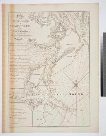
A Plan of the River and Sound of D'Awfoskee, in South Carolina. Survey'd by Captain John Gascoigne
Visual Materials
MS note: c 36. Prime meridian: London. Relief: no. Graphic Scale: Miles. Projection: Plane. Watermark: Crowned fleur-di-lis VI. Printing Process: Copper engraving. Verso Text: MS note: 349 10.
105:349 M
Image not available
An Exact Plan of Charleston Bar and Harbour. From an Actual Survey. With the attack of Fort Sulivan, on the 28th of June 1776. by His Majesty's Squadron. Commanded by Sir Peter Parker
Visual Materials
Kashnor notes, "Indicates the vessels engaged, giving partuculars of their guns, commanders, and casualties. A very fine plan." Relief: no. Graphic Scale: Miles. Projection: Plane. Watermark: Crowned fleur-di-lis VI. Printing Process: Copper engraving. Verso Text: 8 MS note: 319.
105:319 M
Image not available
Quebek De Hoofstad van Kanada; aan de Rivier van St.Laurens: door de Engelschen belegero en by Verdrag bemagtigd, in't jaar 1759
Visual Materials
Kashnor notes, " A rare Dutch plan of the fall of Quebec." Submap of St. Lawrence River. Another copy of Jefferys map, see 093:328, etc. Kashnor dates as circa 1760. Submap: De Rivier boven Quebek.. Relief: hachures. Graphic Scale: Miles. Projection: Plane. Watermark: Crowned fleur-di-lis Van Der Ley. Printing Process: Copper engraving. Other Features: CartoucheSub-maps. Verso Text: MS note: 330.
093:330 M
Image not available
A New and Correct Map of North America with the West India Islands, divided According to the Last Treaty of Peace concluded at Paris 10th Feby.1763, wherein are particularly Distinguished The Several Provinces and Colonies which compose the British Empire, Laid down according to the latest Surveys, and Corrected from the Original Materials, of Govrnr. Pownall, Membr. of Parliamt. 1777
Visual Materials
Insert maps of Baffin's and Hudson's Bays, copy of Kino's map. For a later version (1794) see 105:269M and also 093:218M (1786) and 093:199 a variation. Cartouche w. alligator. Text of Articles 4 through 9, 17, 18 and 20 of Treaty of 1763. Submap: A Particular Map of Baffin & Hudson's Bay. A Passage by Land to California.. Prime meridian: Ferro. Relief: pictorial. Graphic Scale: Miles, leagues. Projection: Pseudocylindrical. Watermark: WF RG Crowned fleur di lis. Printing Process: Copper engraving. Other Features: CartoucheSub-maps. Verso Text: 30 MS notes: 445 Pownall N. America .
105:445 M
Image not available
A Chart of the Bay and Harbour of Pensacola, in the Province of West Florida, Surveyed by George Gould, A.M. Published by Command of Government by J. F. W. Des Barres Esqr
Visual Materials
Kashnor notes, "Exceedingly rare, and one of the most rare of Des Barres war charts. Only a few other copies appear to be known, and there is no record of a coloured impression." MS note: 75. Prime meridian: GM. Relief: hachures. Graphic Scale: Miles. Projection: Plane. Watermark: Crowned fleur-di-lis over JVC VI. Printing Process: Copper engraving. Verso Text: MS note:990.
105:990 M