Visual Materials
A Plan of the River and Sound of D'Awfoskee, in South Carolina. Survey'd by Captain John Gascoigne

You might also be interested in
Image not available
A Plan of Cape Fear River from the Bar to Brunswick
Visual Materials
Kashnor notes, "A very scarce chart. It was reissued in 1800 by Laurie & Whittle." MS note: c 38. Prime meridian: London. Relief: no. Graphic Scale: Miles. Projection: Plane. Watermark: Crowned fleur-di-lis VI. Printing Process: Copper engraving. Verso Text: MS notes: 347 7.
105:347 M
Image not available
An Exact Plan of Charleston Bar and Harbour. From an Actual Survey. With the attack of Fort Sulivan, on the 28th of June 1776. by His Majesty's Squadron. Commanded by Sir Peter Parker
Visual Materials
Kashnor notes, "Indicates the vessels engaged, giving partuculars of their guns, commanders, and casualties. A very fine plan." Relief: no. Graphic Scale: Miles. Projection: Plane. Watermark: Crowned fleur-di-lis VI. Printing Process: Copper engraving. Verso Text: 8 MS note: 319.
105:319 M

Plan of Bahia Honda. ; Plan of Puerto de Cavañas
Visual Materials
Two maps on one sheet. Kashnor dates as ca. 1760. MS notes: 68 69 (upper right). Relief: hachures. Graphic Scale: Miles. Projection: Plane. Watermark: Crowned fleur-di-lis. Printing Process: Copper engraving. Verso Text: MS note: 375.
105:375 M
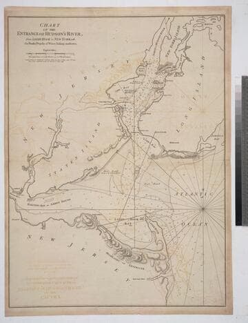
Chart of the Entrance of Hudson's River, from Sandy Hook to New York, with the Banks, Depths of Water, Sailing-marks &ca
Visual Materials
Kashnor notes, " The first issue of this chart. It was reissued in 1800 by Laurie & Whittle, but without date." Relief: hachures. Graphic Scale: Miles. Projection: Plane. Watermark: Crowned fleur-di-lis VI. Printing Process: Copper engraving. Verso Text: MS notes: 3 578.
105:578 M

Authentic Plan of the Tolwn and Harbour of Cap-Francois in the Isle of St. Domingo. By Thomas Jefferys Geographer to His Royal Highness the Prince of Wales
Visual Materials
MS note: 779. Relief: hachures. Graphic Scale: Fathoms. Projection: Plane. Watermark: Crowned fleur-de-lis over LVG VI. Printing Process: Copper engraving.
093:779 M

Plan of Amelia Harbour and Barr in East Florida
Visual Materials
Kashnor notes, "Shows the ruins of old Fort William on Cumberland Island, built by General Oglethorpe." Amelia Harbor is on the border between Florida and Georgia. See 105:101 for a later French version of this map. Sailing directions given.. Relief: no. Graphic Scale: Miles. Projection: Plane. Watermark: Crowned fleur-di-lis VI. Printing Process: Copper engraving. Verso Text: MS note: 94.
105:094 M