Visual Materials
Plan of Bahia Honda. ; Plan of Puerto de Cavañas

You might also be interested in
Image not available
Quebek De Hoofstad van Kanada; aan de Rivier van St.Laurens: door de Engelschen belegero en by Verdrag bemagtigd, in't jaar 1759
Visual Materials
Kashnor notes, " A rare Dutch plan of the fall of Quebec." Submap of St. Lawrence River. Another copy of Jefferys map, see 093:328, etc. Kashnor dates as circa 1760. Submap: De Rivier boven Quebek.. Relief: hachures. Graphic Scale: Miles. Projection: Plane. Watermark: Crowned fleur-di-lis Van Der Ley. Printing Process: Copper engraving. Other Features: CartoucheSub-maps. Verso Text: MS note: 330.
093:330 M
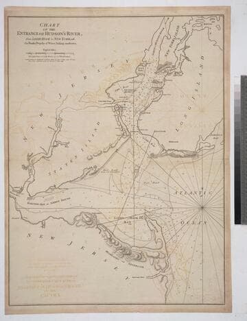
Chart of the Entrance of Hudson's River, from Sandy Hook to New York, with the Banks, Depths of Water, Sailing-marks &ca
Visual Materials
Kashnor notes, " The first issue of this chart. It was reissued in 1800 by Laurie & Whittle, but without date." Relief: hachures. Graphic Scale: Miles. Projection: Plane. Watermark: Crowned fleur-di-lis VI. Printing Process: Copper engraving. Verso Text: MS notes: 3 578.
105:578 M
Image not available
A Plan of Cape Fear River from the Bar to Brunswick
Visual Materials
Kashnor notes, "A very scarce chart. It was reissued in 1800 by Laurie & Whittle." MS note: c 38. Prime meridian: London. Relief: no. Graphic Scale: Miles. Projection: Plane. Watermark: Crowned fleur-di-lis VI. Printing Process: Copper engraving. Verso Text: MS notes: 347 7.
105:347 M

A Plan of the Harbour of St. Augustin in the Province of Georgia
Visual Materials
Kashnor notes, "A very rare chart issued for the commanders of ships of war during the Revolution. It shows a very good plan of the city of St. Augustin, with Fort St. Mark and the fortifications. Coloured impressions are very rare." Kashnor dates ca. 1780. Relief: hachures. Graphic Scale: Miles, feet. Projection: Plane. Watermark: Crowned fleur-di-lis J. Bates. Printing Process: Copper engraving. Verso Text: MS note: 991.
105:991 M

Plan of the Operations of the King's Army under the Command of General Sr. William HoWe, K.B. in NeW York and East NeW Jersey, against the American Forces Commanded by General Washington, From the 12th. of October, to the 28th. of November 1776
Visual Materials
Kashnor notes, "An exceedingly rare plan of one of the most famous engagements during the American Revolution." Relief: hachures. Graphic Scale: Miles. Projection: Plane. Watermark: CroWned fleur-di-lis W F. Printing Process: Copper engraving. Verso Text: MS notes: 109 JS.
093:109 M
Image not available
An Exact Plan of Charleston Bar and Harbour. From an Actual Survey. With the attack of Fort Sulivan, on the 28th of June 1776. by His Majesty's Squadron. Commanded by Sir Peter Parker
Visual Materials
Kashnor notes, "Indicates the vessels engaged, giving partuculars of their guns, commanders, and casualties. A very fine plan." Relief: no. Graphic Scale: Miles. Projection: Plane. Watermark: Crowned fleur-di-lis VI. Printing Process: Copper engraving. Verso Text: 8 MS note: 319.
105:319 M