Visual Materials
Plan of Amelia Harbour and Barr in East Florida

You might also be interested in

Plan of Amelia Island in East Florida - Part of Cumberland Island Georgia - Chart of the Mouth of Nassau River
Visual Materials
Kashnor notes, "A rare sheet of charts. It was issued for the use of navigators and captains of ships-of-war during the Revolution." See 105:095 for a French copy of this map. RLIN record corrects publication date to 1777, gives appeared in information. Three maps plus view of the entry to the St. Mary's River. . Relief: no. Graphic Scale: Miles. Projection: Plane. Watermark: Crowned fleur-di-lis WF. Printing Process: Copper engraving. Verso Text: MS notes: 105-100 31 013.
105:100 M
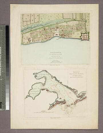
Plan of the Town of St. Augustine the Capital of East Florida. - The Bay of Espiritu Santo, on the Western Coast of East Florida
Visual Materials
Kashnor notes date as [circa 1777]. See 105:096S for French copy. See also 093:390S for another copy. Apparently switched with 093:390S (see MS notes) Graphic Scale: Miles, furlongs. Projection: Plane. Watermark: Crowned fleur-di-lis. Printing Process: Copper engraving. Verso Text: MS note: 390.
105:097 S
Image not available
A Chart of the Bay and Harbour of Pensacola, in the Province of West Florida, Surveyed by George Gould, A.M. Published by Command of Government by J. F. W. Des Barres Esqr
Visual Materials
Kashnor notes, "Exceedingly rare, and one of the most rare of Des Barres war charts. Only a few other copies appear to be known, and there is no record of a coloured impression." MS note: 75. Prime meridian: GM. Relief: hachures. Graphic Scale: Miles. Projection: Plane. Watermark: Crowned fleur-di-lis over JVC VI. Printing Process: Copper engraving. Verso Text: MS note:990.
105:990 M
Image not available
An Exact Plan of Charleston Bar and Harbour. From an Actual Survey. With the attack of Fort Sulivan, on the 28th of June 1776. by His Majesty's Squadron. Commanded by Sir Peter Parker
Visual Materials
Kashnor notes, "Indicates the vessels engaged, giving partuculars of their guns, commanders, and casualties. A very fine plan." Relief: no. Graphic Scale: Miles. Projection: Plane. Watermark: Crowned fleur-di-lis VI. Printing Process: Copper engraving. Verso Text: 8 MS note: 319.
105:319 M
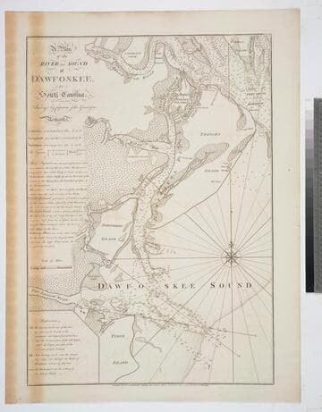
A Plan of the River and Sound of D'Awfoskee, in South Carolina. Survey'd by Captain John Gascoigne
Visual Materials
MS note: c 36. Prime meridian: London. Relief: no. Graphic Scale: Miles. Projection: Plane. Watermark: Crowned fleur-di-lis VI. Printing Process: Copper engraving. Verso Text: MS note: 349 10.
105:349 M

The Coast of West Florida and Louisiana by Thos. Jefferys, Geographer to His Majesty.: Peninsula and Gulf of Florida or Channel of Bahama with Bahama Islands, by Thos. Jefferys, Geographer to His Masjesty
Visual Materials
Two maps spliced to form one map. See 105:392 for a later version. See 105:393-Dup. for another copy. Prime meridian: London. Relief: pictorial. Projection: Cylindrical. Watermark: Crowned fluer-di-lis VI. Printing Process: Copper engraving. Verso Text: MS notes: 393.
105:393 M