Visual Materials
Plan of Amelia Island in East Florida - Part of Cumberland Island Georgia - Chart of the Mouth of Nassau River

You might also be interested in

Plan of Amelia Harbour and Barr in East Florida
Visual Materials
Kashnor notes, "Shows the ruins of old Fort William on Cumberland Island, built by General Oglethorpe." Amelia Harbor is on the border between Florida and Georgia. See 105:101 for a later French version of this map. Sailing directions given.. Relief: no. Graphic Scale: Miles. Projection: Plane. Watermark: Crowned fleur-di-lis VI. Printing Process: Copper engraving. Verso Text: MS note: 94.
105:094 M

Chart of the Entrance to Hudson's River, from Sandy Hook to New York, with the Banks, Depths of Water, Sailing-marks, &ca
Visual Materials
Kashnor notes, "A scarce chart, issued during the early period of the American Revolution." Found in North-American pilot for New England, New York, Pensilvania (sic), Maryland, and Virginia 1777, per RLIN record. Relief: hachures. Graphic Scale: Miles, English. Projection: Plane. Watermark: Crowned fleur-di-lis. Printing Process: Copper engraving. References: Phillips 1209. Verso Text: MS note: 105.
093:105 M
Image not available
Chart of the Harbour of Boston, with the Soundings, Sailing-Marks and Other Directions
Visual Materials
Kashnor notes, "From the indications, Ruins of Charlestown, this map must have been executed about 1776." RLIN record suggests ca. 1777 and give publisher information. This map may be a source map for 105:064M. Relief: hachures. Graphic Scale: Miles, nautical. Projection: Plane. Watermark: Crowned fleur-di-lis. Printing Process: Copper engraving. Verso Text: MS notes: 65 2.
105:065 M
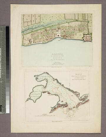
Plan of the Town of St. Augustine the Capital of East Florida. - The Bay of Espiritu Santo, on the Western Coast of East Florida
Visual Materials
Kashnor notes date as [circa 1777]. See 105:096S for French copy. See also 093:390S for another copy. Apparently switched with 093:390S (see MS notes) Graphic Scale: Miles, furlongs. Projection: Plane. Watermark: Crowned fleur-di-lis. Printing Process: Copper engraving. Verso Text: MS note: 390.
105:097 S
Image not available
Isle Amelia en Florida - Isle Cumberland en Georgia
Visual Materials
Kashnor notes, "A scarce sheet of charts issued for the use of the French Navy and transports during the Revolution." Border area between Florida and Georgia. Appeared in from RLIN record. This map is a copy of Jefferys' original map, 105:100. Three maps plus view of the entry to the St. Mary's River. . Relief: pictorial & hachures. Graphic Scale: Miles. Projection: Plane. Watermark: Chained Maltese cross lettering. Printing Process: Copper engraving. Other Features: Sub-maps. Verso Text: MS note: 95.
105:095 M
Image not available
Plan of the Town of St. Augustine the Capital of East Florida. - The Bay of Espiritu Santo, on the Western Coast of East Florida
Visual Materials
Kashnor notes date as [circa 1777]. See 105:096S for French copy. See also 105:097S for another copy. Note that 093:390 and 105:097 seem to have been interchanged at some earlier date (see MS notes). Also they differ in the order of the two plates, one is printed with the city view on the top, the other below the bay view. Graphic Scale: Miles, furlongs. Projection: Plane. Watermark: Crowned fleur-di-lis. Printing Process: Copper engraving. Verso Text: MS note: 97.
093:390 S