Visual Materials
Plan of the Town of St. Augustine the Capital of East Florida. - The Bay of Espiritu Santo, on the Western Coast of East Florida
You might also be interested in
Plan of the Town of St. Augustine the Capital of East Florida. - The Bay of Espiritu Santo, on the Western Coast of East Florida
Visual Materials
Kashnor notes date as [circa 1777]. See 105:096S for French copy. See also 093:390S for another copy. Apparently switched with 093:390S (see MS notes) Graphic Scale: Miles, furlongs. Projection: Plane. Watermark: Crowned fleur-di-lis. Printing Process: Copper engraving. Verso Text: MS note: 390.
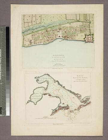
105:097 S

Plan of the Town and Harbour of St. Augustin, in East Florida
Visual Materials
MS note: 396 (on backing). Relief: pictorial. Graphic Scale: Miles. Projection: Plane. Printing Process: Copper engraving. References: Jolly British Period. Pol. 71.
105:396 S
La Baye de Spititu Santo Côte Occidentale De la Floride - S. Augustin Capitale de la floride orientale
Visual Materials
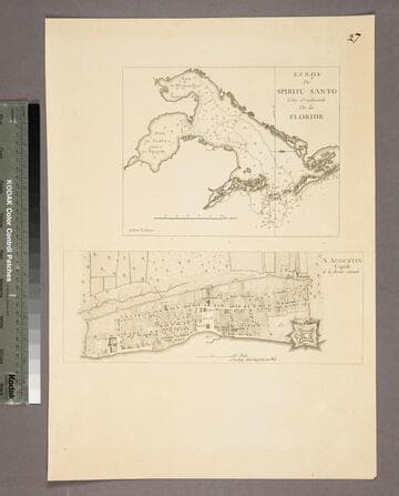
Kashnor notes, "Both chart and plan are copied from Jefferys. The were issued by Le Rouge for the use of French navigators during the Revolution." Kashnor dates as [1778]. See 105:097S for original maps. Two maps on one sheet. MS note: 27. Relief: no. Graphic Scale: Miles, furlongs. Projection: Plane. Watermark: Lettering. Printing Process: Copper engraving. Other Features: Sub-maps. Verso Text: MS note: 96.
105:096 S

Plan of Amelia Island in East Florida - Part of Cumberland Island Georgia - Chart of the Mouth of Nassau River
Visual Materials
Kashnor notes, "A rare sheet of charts. It was issued for the use of navigators and captains of ships-of-war during the Revolution." See 105:095 for a French copy of this map. RLIN record corrects publication date to 1777, gives appeared in information. Three maps plus view of the entry to the St. Mary's River. . Relief: no. Graphic Scale: Miles. Projection: Plane. Watermark: Crowned fleur-di-lis WF. Printing Process: Copper engraving. Verso Text: MS notes: 105-100 31 013.
105:100 M
Image not available
Plan of the Town and Fortifications of Montreal or Ville Marie in Canada
Visual Materials
Kashnor notes, "a rare map issued during the Old French War." Publication date and place from 093:299, a larger engraving of the same material. This smaller version without that information corresponds to the RLIN record. See also 105:664s for another version. Detailed city plan. MS note: 300 (on backing). Relief: hachures. Graphic Scale: Toises, Yards. Projection: Plane. Printing Process: Copper engraving. Other Features: Cartouche. Verso Text: MS note: 300 (on backing).
093:300 S
Image not available
A plan & view of the town and fortifications of Montreal in Canada
Visual Materials
This is a later copy of Jeffrey's map with added city view. See 093:299 and 093:300. MS note: 302 (on backing). View of city with British flag flying from the fort. Relief: hachures. Graphic Scale: Toises, Yards. Projection: Plane. Verso Text: MS note: 302 (on backing).
093:302 S