Visual Materials
Plan of the Town and Harbour of St. Augustin, in East Florida

You might also be interested in

An Accurate Map of the Island of St. Christophers
Visual Materials
"from an Actual Survey; Shewing the Parishes,Churches and Rivers; Also the Bays, Rocks,. Shoals, and Soundings, that Surround the Whole." "Jno. Lodge Sculp. Political Mag. March 1782" MS note: 774 (on backing). Relief: pictorial. Graphic Scale: Miles. Projection: Plane. Watermark: Two seals GR. Printing Process: Copper engraving. References: Jolly Brit. Period. Pol-48;.
105:774 S

A New Map of the Cherokee Nation with the Names of the Towns & Rivers, They are situated on No. Lat. from 34 to 36
Visual Materials
Kashnor dates as ca. 1790. Jolly confirms printed February 1760. See also 093:392S for another copy. MS note: 400 (on backing). Relief: pictorial. Graphic Scale: Miles. Projection: Plane. Printing Process: Copper engraving. References: Jolly, Brit. Periodicals Lond - 183..
105:400 S

A plan of the late siege of the Havana : and Moor's Castle, & their Environs
Visual Materials
Kashnor notes, "Havana was taken in 1762, but restored to Spain in the following year." Jolly gives year of publication. MS note: 387 (on backing). Relief: pictorial. Graphic Scale: Miles. Projection: Plane. Printing Process: Copper engraving. References: Jolly British Publications LOND-223.
105:387 S
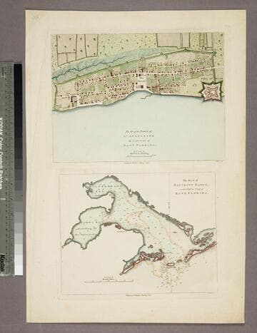
Plan of the Town of St. Augustine the Capital of East Florida. - The Bay of Espiritu Santo, on the Western Coast of East Florida
Visual Materials
Kashnor notes date as [circa 1777]. See 105:096S for French copy. See also 093:390S for another copy. Apparently switched with 093:390S (see MS notes) Graphic Scale: Miles, furlongs. Projection: Plane. Watermark: Crowned fleur-di-lis. Printing Process: Copper engraving. Verso Text: MS note: 390.
105:097 S
Image not available
Plan of the Town and Harbour of Halifax in Nova Scotia
Visual Materials
Kashnor notes, "A small but scarce plan." MS note: 273 (on backing). Relief: hachures. Graphic Scale: Miles. Projection: Plane. Printing Process: Copper engraving. References: Kershaw 824. Verso Text: MS note: 273 (on backing).
093:273 S

Island of St. Christophers, alias St. Kitts by H. Moll Geographer 1729
Visual Materials
MS note: 775 (on backing). Prime meridian: London. Relief: pictorial. Graphic Scale: Miles. Projection: Plane. Printing Process: Copper engraving.
105:775 S