Visual Materials
An Accurate Map of the Island of St. Christophers

You might also be interested in
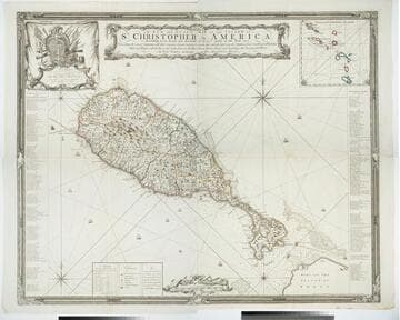
A New and Exact Map of the Island of St. Christopher in America
Visual Materials
One map on four sheets. Cartouche: Vined columns. Jams. Mynde Sculp. Dedication: Military decorations. Table: An Alphabetical List of the Subscribers Names. Submap: The Leeward Caribee Islands. Table of areas of each Parish.. "According to an Actual and Accurate Survey made in the Year 1753. Describing the several Parishes with their respective limits, Contents, & Churches, also the high ways, the Situation of every Gentleman's Plantation, Mills and Houses; with the Rivers, and Gutts. Likewise the Bays, Roads, Rocks, Shoals and Soundings that Surround the Whole. By Saml. Baker Lieutenant in His Majesty's Navy." "To the Right Honble. The Lords Commissioners for Executing the Office of Lord High Admiral of Great Britain &c. This map is most humbly Dedicated By their Lordships most Obedient humble Servt. Saml. Baker." Relief: pictorial. Graphic Scale: Miles. Projection: Plane. Printing Process: Copper engraving. Verso Text: MS notes: 7, 8, 9, 10 778 four sheets.
105:778 M
Image not available
An accurate map of the English Colonies in North America bordering on the River Ohio
Visual Materials
MS notes: 619 Universal Magazine Dec 1754 p241 (on backing). Prime meridian: Ferro. Relief: pictorial. Projection: Cylindrical. Printing Process: Copper engraving. References: Jolly Brit Per. Univ-41.
105:619 S
Image not available
A map of the country round Philadelphia : including part of New Jersey New York Staten Island & Long Island
Visual Materials
Kashnor dates as ca. 1760. Jolly identifies as from Gentleman's Magazine, of Sept. 1776 [as does printing transfer on verso]. MS note: 729 (on backing). Prime meridian: London. Relief: pictorial. Graphic Scale: Miles. Projection: Cylindrical. Printing Process: Copper engraving. References: Jolly, Brit. Periodicals Gent-247. Verso Text: Text transfer.
105:729 S

A New and Accurate Map of Virginia, and Part of Maryland and Pennsylvania
Visual Materials
Kashnor notes, "This takes in also the Delaware Counties and part of New Jersey. A scarce map, issued during the Revolution." "Jno. Lodge Sculp." Appeared in information from RLIN record. MS note: 515 (on backing). Prime meridian: London. Relief: pictorial. Projection: Mercator. Printing Process: Copper engraving.
105:515 S

Plan of the town & fort of Grenada / by Mr. de Caylus, Engineer General of the French Islands
Visual Materials
Kashnor dates as ca. 1760. Jolly notes publication date as December 1762. Submap of island. Submap: The Isle of Grenada. MS note: 404 (on backing). Relief: hachures. Graphic Scale: Fathoms. Projection: Plane. Printing Process: Copper engraving. References: Jolly, Brit. Periodicals LOND - 219.
105:404 S

A NeW and Accurate Map of the Province of NeW York and Part of the Jerseys, NeW England and Canada, SheWing the Scenes of our Military Operations during the present War, Also the NeW Erected State of Vermont
Visual Materials
Kashnor states, "J. BeW, Oct.31, 1780" [from another copy, this one trimmed to the neatline]. Information confirmed by McCorkle, along With engraver and appeared in information. MS note: 812 (on backing). Prime meridian: London. Relief: pictorial. Projection: Cylindrical. Printing Process: Copper engraving. References: McCorkle 780.9, Jolly I: Pol 14. Verso Text: MS note: 812 partial reverse printed text. .
105:812 S