Visual Materials
A New and Exact Map of the Island of St. Christopher in America

You might also be interested in
Image not available
A Chart Shewing Part of the Sea Coast of New Foundland From the Bay of Bulls to little Placentia exactly and Carefully lay'd down by John Gaudy
Visual Materials
Kashnor notes Mount & Page as publishers and dates as ca. 1750. A poorly printed map. Submap of the Harbour of Trepasseyin. Submap: Harbour of Trepassiyen, Newfoundland.. "To the Right Honourable the Lords Commissioners for executing the Office of Lord High Admiral of Great Britain and Ireland &c. This draught is most humbly Dedicated and Presented by their most Obedt. and most humble Servt. John Gaudy." Relief: no. Graphic Scale: Leaguea. Projection: Plane. Printing Process: Copper engraving. Verso Text: MS note: 555 penciled square.
105:555 M
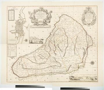
New and Exact Map of the Island of Barbadoes in America, According to an Actual and Accurate Survey made by William Mayo
Visual Materials
Kashnor notes, "Dedicated to James Bridges, Duke of Chandos. With inset plan of Bridgetown, prospect of Codrington College, and engraving representing the making of the survey; also statistics of population." See also 093:745M, another copy as engraved by John Senex 1722. Two elaborate cartouches. Submap - A Plan of Bridgetown. A view of Codrington College. View of surveyor with plane table, and native assistants with measuring wheel, surveying pole and chain. . Prime meridian: London. Relief: pictorial. Graphic Scale: Miles. Projection: Plane. Watermark: JW Whatman 1794. Printing Process: Copper engraving. Other Features: CartoucheSub-mapsVignettes. Verso Text: Ms notes: 174 4 sheets 23, 24, 25, 26..
105:174 M
Image not available
A Map of the Island of St. John In the Gulf of St. Laurence
Visual Materials
This map follows 105:754 in production. A list of Lots with Proprietor's names is added and the map title moved. Submap: Gulf of St. Laurence. Table: the Contents of the Respective Divisions of the Island of St. John. A list of Lots and Proprietor's Names.. "divided into Counties & Parishes and the Lots as granted by Government to which are added the Soundings round the Coast and Harbours Improved from the late Survey of Captain Holland. Published as the Act directs April 6, 1775." Prime meridian: London. Relief: no. Graphic Scale: Miles. Projection: Plane. Watermark: Crowned fleur-di-lis WF. Printing Process: Copper engraving. Verso Text: MS notes: 755.
105:755 M
Image not available
A New and Accurate Map of North America
Rare Books
A version of Kitchin's map. Note South Carolina is split in two sections. Cartouche: framed with coat of arms. Sub map: Map of Hudsons Bay &c. MS note: 140842. "(wherein the Errors of all proceeding British, French, and Dutch Maps, respecting the rights of Great Britain, France & Spain, & the Limits of each of His Majesty's Provinices, are Corrected) Humbly Inscribed to the Honourable Charles Townshend, one of the Right Honourable Lords Commissioners for Executing the Office of Lord High Admiral of Great Britain &c. By his Most Obliged, most Obedient and Very Humble Servant Huske." "Tho: Kitchin Sculpt." Prime meridian: London. Relief: pictorial. Graphic Scale: Miles, leagues. Projection: Pseudocylindrical. Printing Process: Copper engraving. Other Features: Cartouche Sub-maps.
140842
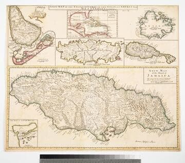
Map of the English Empire in the Ocean of America or West Indies, revised by J. Senex; A New Map of the Island of Jamaica; Barbados & Bermuda; Tobago; Antego; St. Christophers; Harbour at Port Royall
Visual Materials
Kashnor notes," The map of Bermuda locates all the tribes." This map is eight maps on one sheet. See 105:192 for earlier version of this map. Eight maps on one sheet. MS notes: 10 Sen 0 Savanna, signifies a Plain . Relief: pictorial. Graphic Scale: varies. Projection: Plane. Printing Process: Copper engraving. Other Features: Sub-maps. Verso Text: MS note: 191.
105:191 M
Image not available
A New Map of Carolina
Visual Materials
Kashnor notes, "An important map, showing the exact state of the settlements in Carolina at the close of the XVII century. The inset map of Ashley River shows the names and locations of thirty-seven settlers." Kashnor dates as ca. 1680. Submap: A particular map for going into Ashley and Cooper Rivers. Table lists 33 settlers.. Prime meridian: London. Relief: pictorial. Graphic Scale: Miles. Projection: Cylindrical. Watermark: KO?. Printing Process: Copper engraving. Other Features: Sub-maps. Verso Text: MS notes: 96 105:336.
105:336 M