Visual Materials
A Chart Shewing Part of the Sea Coast of New Foundland From the Bay of Bulls to little Placentia exactly and Carefully lay'd down by John Gaudy
You might also be interested in
Image not available
A Chart of the Bay of Placentia, on the South Coast of Newfoundland
Visual Materials
"Surveyed by Order of Commodore Shuldham, Governor of Newfoundland, Labradore, &c. by Mich. Lane, 1772.""Engraved by Faden & Jefferys Geographer to the King. Published by permission of the Right Honourable the Lords Commissioners of the Admiralty." Includes submap surveyed by James Cook. Submaps: Burin Harbours; Harbour of Placentia Surveyed by James Cook; View: Section of the Channel going into the Harbour.. Relief: hachures. Graphic Scale: Leagues. Projection: Plane. Watermark: W. Turner. Printing Process: Copper engraving. Other Features: Sub-mapsVignettes. Verso Text: MS note: 550.
105:550 M
Image not available
A Chart of the Harbour of Halifax, in Nova Scotia; with Jebucto Bay and Cape Sambro. also the Islands, Ledges of Rocks, Shoals & Soundings
Visual Materials
Kashnor notes, "The first issue of the Morris chart. It is the first separate chart of Halifax Harbour." The publication date is 1775 but Kashnor dates the map at [1760]. Includes sailing directions. Kershaw gives appeared in information and notes this is the second state of Jefferys' map. Detailed sailing directions.. "Survey'd by Order of His Excellency Brigadier General Lawrence, Governour of the Province of Nova Scotia; By Charles Morris, Chief Surveyor, Published by Command of the Rgiht Honourable the Lords of Trade & Plantations, For the Benefit of the Trade and Navigation of Great Britain and its Colonies." "To the Right Honourable George Dunk Earl of Halifax, First Lord Commissioner, and to the rest of the Right Honourable and Honourable Commissioners for Trade and Plantations, This Chart is most humbly Inscribed By their most obliged & obedient humble Sert. Thos. Jefferys." "London Engraved by Thomas Jefferys, Geographer to the King." Relief: hachures. Graphic Scale: Miles. Projection: Plane. Watermark: Crowned fluer-di-lis VI. Printing Process: Copper engraving. References: Kershaw 821. Verso Text: Ms note: 20.
105:660 M
Image not available
A Chart of the Straits of Bellisle with part of the coast of Newfoundland and Labradore from actual surveys
Visual Materials
"Published by Permission of the Right Honourable the Lords Commissioners of the Admiralty and taken in 1766, by James Cook, afterwards Capt. Cook, the Celebrated Circumnavigator, and by Michael Lane in 1769." Submaps and sailing directions for the Straits of Bellisle. See 105:564M for a French copy of this map. Submaps: Bradhore Harbour; Red Bay; York, or Chateaux Bay; Cape Degrat; Croque Harbour; Old Ferrole Harbour.. Relief: hachures. Graphic Scale: Leagues. Projection: Plane. Printing Process: Copper engraving. Other Features: Sub-maps. Verso Text: MS note: 553.
105:553 M
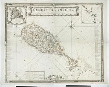
A New and Exact Map of the Island of St. Christopher in America
Visual Materials
One map on four sheets. Cartouche: Vined columns. Jams. Mynde Sculp. Dedication: Military decorations. Table: An Alphabetical List of the Subscribers Names. Submap: The Leeward Caribee Islands. Table of areas of each Parish.. "According to an Actual and Accurate Survey made in the Year 1753. Describing the several Parishes with their respective limits, Contents, & Churches, also the high ways, the Situation of every Gentleman's Plantation, Mills and Houses; with the Rivers, and Gutts. Likewise the Bays, Roads, Rocks, Shoals and Soundings that Surround the Whole. By Saml. Baker Lieutenant in His Majesty's Navy." "To the Right Honble. The Lords Commissioners for Executing the Office of Lord High Admiral of Great Britain &c. This map is most humbly Dedicated By their Lordships most Obedient humble Servt. Saml. Baker." Relief: pictorial. Graphic Scale: Miles. Projection: Plane. Printing Process: Copper engraving. Verso Text: MS notes: 7, 8, 9, 10 778 four sheets.
105:778 M
Image not available
A New and Accurate Chart (from Captain Holland's Surveys) of the North American Coast, for the Navigation between Cape Cod in New England, and the Havanna in the Gulf of Florida
Visual Materials
Submaps of harbors, tables, remarks. This is an earlier edition of RLIN record NYPGR45193985-M. MS notes: 159-160 Submaps: Plan of the Entrance and Harbour of St. Augustin; Plan of the Mouth of the Nassau River; Plan of the Inlet of the St. Mary's River;Plan of the Harbour of Port Royal; Plan of the Bar and Harbour of Charleston; Chart of New York Harbour. Tables of sailing directions. Remarks on Lighthouses.. "Respectfully Inscribed To the Honourable Thomas Jefferson, Vice President of the United States of North America By his most obedient humble Servants, Rt. Laurie & J. Whittle. Fleet Street 1800." "MS note in red: Note. This Chart is accompanied by the Book entitled "Laurie and Whittle's New Sailing Directions for the Coasts and Harbours of North America. An Inproved Edition. 1809." Prime meridian: London. Relief: pictorial. Projection: Mercator. Printing Process: Copper engraving. Other Features: Sub-maps. Verso Text: MS note: 537.
105:537 M
Image not available
A New and Correct Chart of the Coast of New Foundland, from Cape Raze to Cape Bonavista, with Chebucto Harbour in Nova Scotia done from the latest Observations
Visual Materials
Kashnor notes, "a fine chart, one of the earliest published charts of Newfoundland." Lightly printed. Kashnor dates as ca. 1752. Kershaw notes this plate was used till 1775 when "it was extremely worn and the impressions for several of the last editions are poor." Kershaw gives appeared in information. Submaps: Trinity Harbour; St. Johns Harbour; Chedabucto Harbour in Nova Scotia. Relief: no. Graphic Scale: Leagues, Miles. Projection: Plane. Printing Process: Copper engraving. Other Features: Sub-maps. References: Kershaw 523. Verso Text: MS note: 562.
105:562 M