Visual Materials
A Map of the Island of St. John In the Gulf of St. Laurence
You might also be interested in

Plan of the Island of St. John with the divisions of the Counties Parishes & the Lots as granted by Government likewise the Soundings round the Coast and Harbours
Visual Materials
Kashnor notes, "This is the first issue of Holand's map before it passed to Sayer and Bennett." Submap: Gulf of St. Laurence. Table: the Contents of the Respective Divisions of the Island of St. John. Cartouche: Fishing, farming view.. "Surveyed by Capt. Holland 1775." Prime meridian: London. Relief: no. Graphic Scale: Miles. Projection: Plane. Watermark: Crowned fleur-di-lis WF. Printing Process: Copper engraving. Other Features: Sub-mapsCartouche. Verso Text: MS notes: 754 4.
105:754 M
Image not available
Survey of Prince Edward Island
Visual Materials
This map is a derivative map of 105:754, and a corrected version of 105:756. Submaps: Gulf of St. Lawrence; Holland Harbour. Lengthy printed description of the island glued to lower section.. Prime meridian: GM. Relief: no. Graphic Scale: Miles. Projection: Plane. Printing Process: Copper engraving. Other Features: Sub-maps. Verso Text: MS note: 757.
105:757 M
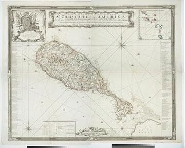
A New and Exact Map of the Island of St. Christopher in America
Visual Materials
One map on four sheets. Cartouche: Vined columns. Jams. Mynde Sculp. Dedication: Military decorations. Table: An Alphabetical List of the Subscribers Names. Submap: The Leeward Caribee Islands. Table of areas of each Parish.. "According to an Actual and Accurate Survey made in the Year 1753. Describing the several Parishes with their respective limits, Contents, & Churches, also the high ways, the Situation of every Gentleman's Plantation, Mills and Houses; with the Rivers, and Gutts. Likewise the Bays, Roads, Rocks, Shoals and Soundings that Surround the Whole. By Saml. Baker Lieutenant in His Majesty's Navy." "To the Right Honble. The Lords Commissioners for Executing the Office of Lord High Admiral of Great Britain &c. This map is most humbly Dedicated By their Lordships most Obedient humble Servt. Saml. Baker." Relief: pictorial. Graphic Scale: Miles. Projection: Plane. Printing Process: Copper engraving. Verso Text: MS notes: 7, 8, 9, 10 778 four sheets.
105:778 M

Survey of Prince Edward Island
Visual Materials
Kashnor notes, "Including soundings, banks, shoals &c., on the coast." This map is a derivative map of 105:754. This map has penciled corrections which then show up on the 1825 corrected version, 105:757. Submaps: Gulf of St. Lawrence; Holland Harbour. Lengthy printed description of the island glued to lower section, partly hiding information provided on 105:757.. Prime meridian: GM. Relief: no. Graphic Scale: Miles. Projection: Plane. Printing Process: Copper engraving. Other Features: Sub-maps. Verso Text: MS note: 756.
105:756 M
Image not available
Steel's New & Accurate Chart of the Coast of North America, from the Straits of Belle Isle to Boston, Including the Islands of Newfoundland, Nova-Scotia & St. John's, the Gulf & River St. Lawrence, Bay of Fundy &c. Compiled from the best and most recent Authorities
Visual Materials
A large navigational chart with both rhumb and grid lines. Several submaps. Submaps of Barrington & Shelburne Harbours, St. Andrew's Harbour. Port of Liverpool, Plan of Cape Canso, Halifax Harbour, (Nova Scotia), St. John's Harbour(Newfoundland), St. John's Harbour(New Brunswick), River St. Lawrence from the English Bank to Quebec, Enlarged view Quebec City, River above Quebec City. List of Lighthouses in New Hampshire and Massachusetts. Views of Cape Chat, Mt. Camel, Funk Island, Young Harry Rock, Cape Bonavista. MS 2 upper right.. Prime meridian: GM. Relief: no. Projection: Mercator. Printing Process: Copper engraving. Other Features: Sub-mapsVignettes. Verso Text: MS note: 275.
093:275 M

New Map of the Island of St. Christophers being an Actual Survey taken by Mr. Andrew Norwood, Surveyr. Genll. By John Thornton at the Sign of England Scotland & Ireland in the Minories London. ; New Map of the Island of Guardalupa. ; New Map of the Island of Martineca
Visual Materials
Kashnor notes, "A rare first issue of Thornton's map. Locates the old plantations, and in many cases, with the owner's names." Three maps on one sheet. Kashnor dates as ca. 1680. Relief: pictorial. Graphic Scale: Miles. Projection: Plane. Printing Process: Copper engraving. Verso Text: MS notes: 778 Thornton St Christophers Il..
105:779