Visual Materials
Survey of Prince Edward Island

You might also be interested in
Image not available
Survey of Prince Edward Island
Visual Materials
This map is a derivative map of 105:754, and a corrected version of 105:756. Submaps: Gulf of St. Lawrence; Holland Harbour. Lengthy printed description of the island glued to lower section.. Prime meridian: GM. Relief: no. Graphic Scale: Miles. Projection: Plane. Printing Process: Copper engraving. Other Features: Sub-maps. Verso Text: MS note: 757.
105:757 M
Image not available
A Map of the Island of St. John In the Gulf of St. Laurence
Visual Materials
This map follows 105:754 in production. A list of Lots with Proprietor's names is added and the map title moved. Submap: Gulf of St. Laurence. Table: the Contents of the Respective Divisions of the Island of St. John. A list of Lots and Proprietor's Names.. "divided into Counties & Parishes and the Lots as granted by Government to which are added the Soundings round the Coast and Harbours Improved from the late Survey of Captain Holland. Published as the Act directs April 6, 1775." Prime meridian: London. Relief: no. Graphic Scale: Miles. Projection: Plane. Watermark: Crowned fleur-di-lis WF. Printing Process: Copper engraving. Verso Text: MS notes: 755.
105:755 M
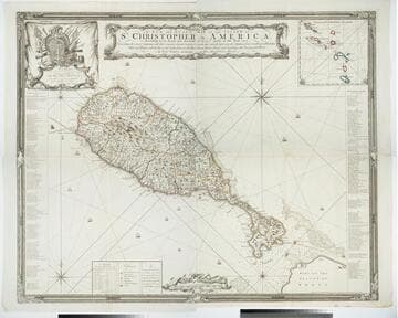
A New and Exact Map of the Island of St. Christopher in America
Visual Materials
One map on four sheets. Cartouche: Vined columns. Jams. Mynde Sculp. Dedication: Military decorations. Table: An Alphabetical List of the Subscribers Names. Submap: The Leeward Caribee Islands. Table of areas of each Parish.. "According to an Actual and Accurate Survey made in the Year 1753. Describing the several Parishes with their respective limits, Contents, & Churches, also the high ways, the Situation of every Gentleman's Plantation, Mills and Houses; with the Rivers, and Gutts. Likewise the Bays, Roads, Rocks, Shoals and Soundings that Surround the Whole. By Saml. Baker Lieutenant in His Majesty's Navy." "To the Right Honble. The Lords Commissioners for Executing the Office of Lord High Admiral of Great Britain &c. This map is most humbly Dedicated By their Lordships most Obedient humble Servt. Saml. Baker." Relief: pictorial. Graphic Scale: Miles. Projection: Plane. Printing Process: Copper engraving. Verso Text: MS notes: 7, 8, 9, 10 778 four sheets.
105:778 M

Antigoa
Visual Materials
Kashnor notes, "Probably an engraved survey of the island. An interesting detailed map, indicating churches, windmills, public ponds, court houses, &c. with the parishes and civil divisions; also rocks, shoals and soundings in the adjacent seas." Kashnor dates circa 1780. Relief: no. Graphic Scale: Miles. Projection: Plane. Watermark: Crowned fluer-di-lis lettering. Printing Process: Copper engraving. Verso Text: MS notes: 153 79.
105:153 M

An Accurate Map of the Island of St. Christophers
Visual Materials
"from an Actual Survey; Shewing the Parishes,Churches and Rivers; Also the Bays, Rocks,. Shoals, and Soundings, that Surround the Whole." "Jno. Lodge Sculp. Political Mag. March 1782" MS note: 774 (on backing). Relief: pictorial. Graphic Scale: Miles. Projection: Plane. Watermark: Two seals GR. Printing Process: Copper engraving. References: Jolly Brit. Period. Pol-48;.
105:774 S

North Atlantic Ocean Bermuda Islands compiled from the most recent Admiralty Surveys
Visual Materials
A detailed marine chart with many soundings. Two submaps; off lying banks and deep soundings; Narrows or Ship Channel and St. George's Harbor. Two submaps. Four compass roses with variation marked.. Prime meridian: GM. Relief: hachures. Projection: Mercator. Watermark: Busbridge & Co. Kent. Printing Process: Engraving. Other Features: Sub-maps. Verso Text: MS notes: No. 85 178 62 Bermuda 13.
105:178 M