Rare Books
A New and Accurate Map of North America
You might also be interested in
Image not available
A New Map of the Whole Continent of America, divided into North and South and West Indies
Rare Books
This map is a later version of the Sayer & Bennett map of 1777, see 093:199M, also 093:218M for 1786 version, 105:269 for a duplicate. Insert map of Baffin's and Hudson's Bays. This map now shows Vancouver Island and corrects the River of the West, adding more exact information about the Pacific Northwest. The provisions of the 1763 Versailles treaty are removed, and instead the "Preliminaries of Peace signed at Versailles Jan 20,1783" are noted. Maine's border revised. See also 150262 (MBS 105:050). Cartouche w. alligator. Table delineating possessions of European nations now revised to include United States information Sub map: The Supplement to North America containing the countries adjoining Baffins & Hudsons Bays. "Compiled from Mr. D'Anville's Maps of that Continent, with the addition of the Spanish Discoveries in 1775 to the North of California & corrected in the Several Parts belonging to Great Britain, from the Original Materials of Governor Pownall, M.P." Prime meridian: Ferro. Relief: pictorial. Graphic Scale: Miles, leagues. Projection: Pseudocylindrical. Watermark: IV RG Crowned fleur di lis. Printing Process: Copper engraving. Other Features: Cartouche Sub-maps. Verso Text: MS notes: 28 29 150261 (sheet 1 & 2).
150261
Image not available
A New and Correct Map of North America with the West India Islands
Rare Books
Similar to but larger than 105:445 Museum Bookstore Collection. Cartouche: Traders at port. Sub maps: A particular Map of Baffin and Hudson's Bay; Passage by Land to California [Kino]. "Divided according to the last treaty of peace concluded at Paris, the 20th of January 1783. Wherein are particularly distinguished the Thirteen Provinces wich [sic.] compose the United States of America." Sticker: 989. Prime meridian: London, Ferro. Relief: pictorial. Graphic Scale: Miles, Leagues. Projection: Pseudocylindrical. Printing Process: Copper engraving. Other Features: Cartouche Sub-maps. Verso Text: MS notes: 989 192560.
192560
Image not available
A New Map of the Whole Continent of America, divided into North and South and West Indies
Rare Books
This map is a later version of the Sayer & Bennett map of 1777, see 093:199M, also 093:218M for 1786 version. Insert map of Baffin's and Hudson's Bays. This map now shows Vancouver Island and corrects the River of the West, adding more exact information about the Pacific Northwest. The provisions of the 1763 Versailles treaty are removed, and instead the "Preliminaries of Peace signed at Versailles Jan 20,1783" are noted. Maine's border revised. Kashnor notes, "One of the earliest maps to show the discoveries of Vancouver, locating the island bearing his name, and the Columbia River. Shows Nootka Sound. The map was issued at a time when the troubles over the Nootka question had lately been settled." This map duplicates 105:269. Cartouche w. alligator. Table delineating possessions of European nations now revised to include United States information Sub-map: The Supplement to North America containing the countries adjoining Baffins & Hudsons Bays. "Compiled from Mr. D'Anville's Maps of that Continent, with the addition of the Spanish Discoveries in 1775 to the North of California & corrected in the Several Parts belonging to Great Britain, from the Original Materials of Governor Pownall, M.P." Prime meridian: Ferro. Relief: pictorial. Graphic Scale: Miles, leagues. Projection: Pseudocylindrical. Printing Process: Copper engraving. Other Features: Cartouche Sub-maps. Verso Text: MS notes: 35 36 50 150262.
150262
Image not available
An Accurate Map of North America
Rare Books
Two sub maps: A Particular Map of Baffin and Hudson's Bay; The Passage by Land to California Discover'd by Father Eusebius Francis Kino.. Voluminous text regarding sections of the treaty and other explanatory details. RLIN record gives appeared in information. Note this is a later printing of the map 093:146 in the Museum Bookstore collection, and is designated 093:147. "Describing and distinguishing the British and Spanish Dominions on this great Continent; according to the Definitive Treaty Concluded at Paris 10th Feby. 1763. Also all the West India Islands belonging to and possessed by the several European Princes and States." "The whole laid down according to the latest and Most authentick Improvements, by Emanuel Bowen, Geogr. to His Majesty And John Gibson Engraver." Elaborate cartouches, on title and scale. Two sub maps. Prime meridian: London, Ferro. Relief: pictorial. Graphic Scale: Miles, leagues. Projection: Pseudocylindrical. Watermark: Crowned fluer-di-lis. Printing Process: Copper engraving. Other Features: Cartouche Sub-maps. Verso Text: MS notes: 149502 147 cat 93 2 sheets [printed] 5 6.
149502

New and Accurate Map of North Carolina in North America
Visual Materials
Kashnor notes,"A scarce map issued during the early days of the American Revolution." Kashnor dates as [1776]. MS note: 376 (on map and backing). Transfer text upper left corner.. Prime meridian: London. Relief: pictorial. Graphic Scale: Miles. Projection: Plane. Watermark: Two seals.. Printing Process: Copper engraving. Other Features: Cartouche. Verso Text: MS note: 11. 376(on backing)..
093:376 S
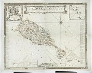
A New and Exact Map of the Island of St. Christopher in America
Visual Materials
One map on four sheets. Cartouche: Vined columns. Jams. Mynde Sculp. Dedication: Military decorations. Table: An Alphabetical List of the Subscribers Names. Submap: The Leeward Caribee Islands. Table of areas of each Parish.. "According to an Actual and Accurate Survey made in the Year 1753. Describing the several Parishes with their respective limits, Contents, & Churches, also the high ways, the Situation of every Gentleman's Plantation, Mills and Houses; with the Rivers, and Gutts. Likewise the Bays, Roads, Rocks, Shoals and Soundings that Surround the Whole. By Saml. Baker Lieutenant in His Majesty's Navy." "To the Right Honble. The Lords Commissioners for Executing the Office of Lord High Admiral of Great Britain &c. This map is most humbly Dedicated By their Lordships most Obedient humble Servt. Saml. Baker." Relief: pictorial. Graphic Scale: Miles. Projection: Plane. Printing Process: Copper engraving. Verso Text: MS notes: 7, 8, 9, 10 778 four sheets.
105:778 M