Rare Books
An Accurate Map of North America
You might also be interested in
Image not available
A New and Correct Map of North America with the West India Islands
Rare Books
Similar to but larger than 105:445 Museum Bookstore Collection. Cartouche: Traders at port. Sub maps: A particular Map of Baffin and Hudson's Bay; Passage by Land to California [Kino]. "Divided according to the last treaty of peace concluded at Paris, the 20th of January 1783. Wherein are particularly distinguished the Thirteen Provinces wich [sic.] compose the United States of America." Sticker: 989. Prime meridian: London, Ferro. Relief: pictorial. Graphic Scale: Miles, Leagues. Projection: Pseudocylindrical. Printing Process: Copper engraving. Other Features: Cartouche Sub-maps. Verso Text: MS notes: 989 192560.
192560
Image not available
A New and Accurate Map of North America
Rare Books
A version of Kitchin's map. Note South Carolina is split in two sections. Cartouche: framed with coat of arms. Sub map: Map of Hudsons Bay &c. MS note: 140842. "(wherein the Errors of all proceeding British, French, and Dutch Maps, respecting the rights of Great Britain, France & Spain, & the Limits of each of His Majesty's Provinices, are Corrected) Humbly Inscribed to the Honourable Charles Townshend, one of the Right Honourable Lords Commissioners for Executing the Office of Lord High Admiral of Great Britain &c. By his Most Obliged, most Obedient and Very Humble Servant Huske." "Tho: Kitchin Sculpt." Prime meridian: London. Relief: pictorial. Graphic Scale: Miles, leagues. Projection: Pseudocylindrical. Printing Process: Copper engraving. Other Features: Cartouche Sub-maps.
140842
Image not available
A New Map of the Whole Continent of America, divided into North and South and West Indies
Rare Books
This map is a later version of the Sayer & Bennett map of 1777, see 093:199M, also 093:218M for 1786 version, 105:269 for a duplicate. Insert map of Baffin's and Hudson's Bays. This map now shows Vancouver Island and corrects the River of the West, adding more exact information about the Pacific Northwest. The provisions of the 1763 Versailles treaty are removed, and instead the "Preliminaries of Peace signed at Versailles Jan 20,1783" are noted. Maine's border revised. See also 150262 (MBS 105:050). Cartouche w. alligator. Table delineating possessions of European nations now revised to include United States information Sub map: The Supplement to North America containing the countries adjoining Baffins & Hudsons Bays. "Compiled from Mr. D'Anville's Maps of that Continent, with the addition of the Spanish Discoveries in 1775 to the North of California & corrected in the Several Parts belonging to Great Britain, from the Original Materials of Governor Pownall, M.P." Prime meridian: Ferro. Relief: pictorial. Graphic Scale: Miles, leagues. Projection: Pseudocylindrical. Watermark: IV RG Crowned fleur di lis. Printing Process: Copper engraving. Other Features: Cartouche Sub-maps. Verso Text: MS notes: 28 29 150261 (sheet 1 & 2).
150261
Image not available
A New Map of the Whole Continent of America, divided into North and South and West Indies
Rare Books
This map is a later version of the Sayer & Bennett map of 1777, see 093:199M, also 093:218M for 1786 version. Insert map of Baffin's and Hudson's Bays. This map now shows Vancouver Island and corrects the River of the West, adding more exact information about the Pacific Northwest. The provisions of the 1763 Versailles treaty are removed, and instead the "Preliminaries of Peace signed at Versailles Jan 20,1783" are noted. Maine's border revised. Kashnor notes, "One of the earliest maps to show the discoveries of Vancouver, locating the island bearing his name, and the Columbia River. Shows Nootka Sound. The map was issued at a time when the troubles over the Nootka question had lately been settled." This map duplicates 105:269. Cartouche w. alligator. Table delineating possessions of European nations now revised to include United States information Sub-map: The Supplement to North America containing the countries adjoining Baffins & Hudsons Bays. "Compiled from Mr. D'Anville's Maps of that Continent, with the addition of the Spanish Discoveries in 1775 to the North of California & corrected in the Several Parts belonging to Great Britain, from the Original Materials of Governor Pownall, M.P." Prime meridian: Ferro. Relief: pictorial. Graphic Scale: Miles, leagues. Projection: Pseudocylindrical. Printing Process: Copper engraving. Other Features: Cartouche Sub-maps. Verso Text: MS notes: 35 36 50 150262.
150262
Image not available
North America and the West Indies;
Visual Materials
Kashnor notes, "An exceedingly rare map, shoWing the country West of the Mississippi, the boundaries of Virginia, North and South Carolina, reaching to that river. The inset map of the country locates Old Forts EdWard, William Henry, Frederic, St. John, and Chamilles to the St. LaWrence, and Albany, Schenectadi, Forts Hunter and OsWego to Lake Ontario." Kashnor dates as ca. 1764. Submaps and treaty articles. See 093:532 for another copy. "a NeWMap, Wherein the British Empire and its limits, according to the difinitive (sic) Treaty of Peace in 1763, are accurately described, and the Dominions possessed by the Spaniards, the French and other European States; the Whole compiled from the NeWSurveys and Authentic Memoirs that have hitherto appeared. " Cartouche With Natives. Submaps: Particular Map of Baffin and Hudson's Bay; Map of the Country betWeen Montreal, Albany and OsWego. Paper sale tag, June 7, 1927 With MS note: #669.. Prime meridian: London, Ferro. Relief: pictorial. Graphic Scale: Miles, Leagues. Projection: Pseudocylindrical. Printing Process: Copper engraving. Other Features: CartoucheSub-mapsFigures .
105:669 M
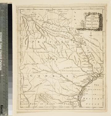
A new and accurate map of the province of Georgia in North America
Visual Materials
Kashnor notes," An old map published about 1775, shewing the roads and Indian paths." Kashnor dates c.1775. Duplicate map to 093:094S, 093:391. RLIN record notes date as [1779?] and place of publication as [London?] and as appearing in The Universal Magazine of 1779. MS note: 103 (on backing). Prime meridian: [Ferro]. Relief: pictorial. Projection: Cylindrical. Watermark: Crowned circular seal. Printing Process: Copper engraving.
105:103 S