Visual Materials
La Baye de Spititu Santo Côte Occidentale De la Floride - S. Augustin Capitale de la floride orientale

You might also be interested in
![Carte de la Floride Occidentale et Louisiane - La Peninsule at Golfe de la Floride ou Canal de Bahama avec les Isles de Bahama [two maps in one]](/_next/image?url=https%3A%2F%2Frail.huntington.org%2FIIIF3%2FImage%2F22APN4KVPDMF%2Ffull%2F%5E360%2C%2F0%2Fdefault.jpg&w=750&q=75)
Carte de la Floride Occidentale et Louisiane - La Peninsule at Golfe de la Floride ou Canal de Bahama avec les Isles de Bahama [two maps in one]
Visual Materials
Kashnor notes, "Copied from Jefferys' fine chart, the best chart of the time for navigators to Florida and the Mississippi. This was issued for the use of French allies during the Revolution." Appeared in reference from RLIN record. Compass rose. Ships on two routes.. Prime meridian: London, Ferro. Relief: pictorial. Graphic Scale: No. Projection: Mercator. Watermark: Chained Maltese cross lettering. Printing Process: Copper engraving. Other Features: Art Work. Verso Text: MS notes: 28 29 98.
105:098 M
Image not available
Partie des Côtes de Labrador Depuis le Cap Charles à la Baye de Sandwich
Visual Materials
Kashnor notes, "A scarce map, issued for the use of French navigators during the Revolution." This map appears to be half of the RLIN record cited. Inset Riviere de Uo.. Relief: no. Graphic Scale: Leagues. Projection: Plane. Watermark: Crowned Maltese cross lettering. Printing Process: Copper engraving. Other Features: Sub-maps. Verso Text: MS note: 104.
105:104 M

Port et Barre d'Amelia. de la Floride Orientale
Visual Materials
Kashnor notes, "Issued for the use of French navigators during the Revolution. It is a rare chart, taken from an English chart, showing the location of plantations." This map is a direct copy of Jacob Blamey's map, 105:094. Appeared in per RLIN record. Relief: no. Graphic Scale: Miles. Projection: Plane. Watermark: Chained Maltese cross lettering. Printing Process: Copper engraving. Verso Text: MS note: 101.
105:101 M
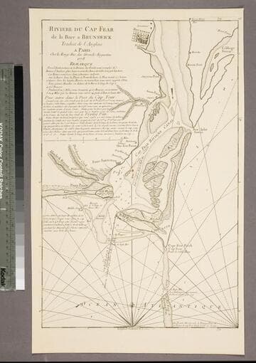
Riviere du Cap Fear de la Bare a Brunswick
Visual Materials
Kashnor notes, "This is copied from Edward Hyrne's chart issued by Jefferys, and was issued for the use of French navigators during the Revolution." Gives sailing directions. Prime meridian: London. Relief: no. Graphic Scale: Miles. Projection: Plane. Watermark: Chained Maltese cross. Printing Process: Copper engraving. Verso Text: MS note: 84.
105:084 S

Isle St. Vincent Levée en 1773. apres le Traité fait avec les Caraibes. Tradut de l'Anglois. A Paris Chez le Rouge rue des Grands Augustins. 1778. avec Privilege du Roi
Visual Materials
Kashnor notes, "A good map by le Rouge (after Jefferys)." Prime meridian: London. Relief: hachures. Graphic Scale: Miles. Projection: Cylindrical. Watermark: Chained maltese cross lettering. Printing Process: Copper engraving. Verso Text: MS note: 832.
093:832 M
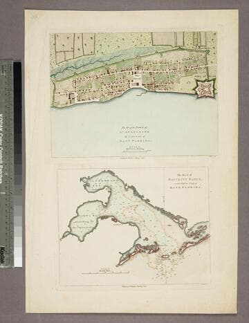
Plan of the Town of St. Augustine the Capital of East Florida. - The Bay of Espiritu Santo, on the Western Coast of East Florida
Visual Materials
Kashnor notes date as [circa 1777]. See 105:096S for French copy. See also 093:390S for another copy. Apparently switched with 093:390S (see MS notes) Graphic Scale: Miles, furlongs. Projection: Plane. Watermark: Crowned fleur-di-lis. Printing Process: Copper engraving. Verso Text: MS note: 390.
105:097 S