Visual Materials
Carte de la Floride Occidentale et Louisiane - La Peninsule at Golfe de la Floride ou Canal de Bahama avec les Isles de Bahama [two maps in one]

You might also be interested in

Port et Barre d'Amelia. de la Floride Orientale
Visual Materials
Kashnor notes, "Issued for the use of French navigators during the Revolution. It is a rare chart, taken from an English chart, showing the location of plantations." This map is a direct copy of Jacob Blamey's map, 105:094. Appeared in per RLIN record. Relief: no. Graphic Scale: Miles. Projection: Plane. Watermark: Chained Maltese cross lettering. Printing Process: Copper engraving. Verso Text: MS note: 101.
105:101 M

Océan Atlantique et Mers Adjacentes en quatre feulles Contenant Les Côtes de l'Europe, de l'Afrique et de l'Amérique
Visual Materials
Kashnor notes, "a scarce map [after Jefferys] issued for the use of the French allies during the Revolution." One map in two sheets. Navigational notes, compass variations, various voyages. Author and appeared in references from RLIN record [this record for upper section] Three compass roses. . Prime meridian: London, Ferro. Relief: no. Graphic Scale: Leagues, Marine. Projection: Mercator. Watermark: Chained Maltese Cross Dupys Moyen(?). Printing Process: Copper engraving. Verso Text: MS notes : 34 (upper) 56 (lower) 63.
105:063 M
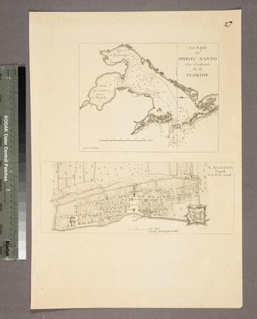
La Baye de Spititu Santo Côte Occidentale De la Floride - S. Augustin Capitale de la floride orientale
Visual Materials
Kashnor notes, "Both chart and plan are copied from Jefferys. The were issued by Le Rouge for the use of French navigators during the Revolution." Kashnor dates as [1778]. See 105:097S for original maps. Two maps on one sheet. MS note: 27. Relief: no. Graphic Scale: Miles, furlongs. Projection: Plane. Watermark: Lettering. Printing Process: Copper engraving. Other Features: Sub-maps. Verso Text: MS note: 96.
105:096 S

Port de Halifax de la Nouvelle Ecosse avec les Recifs, Dangers, Bas fonds et Sondes
Visual Materials
Kashnor notes, "A scarce chart published for the use of commanders of French Ships-of-War during the Revolution. With engraved directions for entering the port." Kershaw says based on Charles Morris's survey of 1759, copied from Jefferys 1768. Kashnor has this item numbered as 135*. Prime meridian: London. Relief: no. Graphic Scale: Miles. Projection: Cylindrical. Watermark: Chained Maltese cross lettering. Printing Process: Copper engraving. References: Kershaw 834. Verso Text: MS note: 135*.
105:135 M
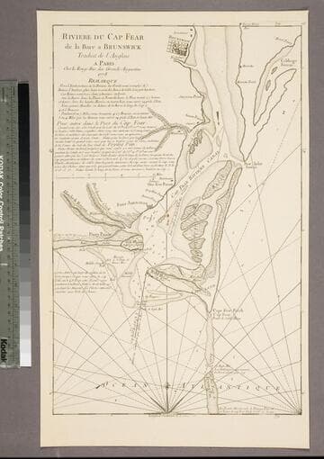
Riviere du Cap Fear de la Bare a Brunswick
Visual Materials
Kashnor notes, "This is copied from Edward Hyrne's chart issued by Jefferys, and was issued for the use of French navigators during the Revolution." Gives sailing directions. Prime meridian: London. Relief: no. Graphic Scale: Miles. Projection: Plane. Watermark: Chained Maltese cross. Printing Process: Copper engraving. Verso Text: MS note: 84.
105:084 S

Nouvelle Carte des Côtes des Carolines Septentrionales et Meridionales du Cap Fear a Sud Edisto
Visual Materials
Kashnor notes, "A scarce chart. It was issued for the use of the officers of French ships-of-war and transports during the American Revolution." Six coastal sectional views. Two ships, Compass rose.. Prime meridian: London. Relief: no. Graphic Scale: Leagues. Projection: Cylindrical. Watermark: Chained Maltese cross lettering. Printing Process: Copper engraving. Other Features: Art Work. Verso Text: MS note: 78.
105:078 M