Visual Materials
Partie des Côtes de Labrador Depuis le Cap Charles à la Baye de Sandwich
You might also be interested in
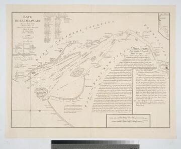
Baye de la Delaware Aved les Ports, Sondes, Dangers, Bancs. &c. depuis les Caps Jusqu'a Philadelphie
Visual Materials
Kashnor notes, "A scarce chart issued for the use of the commanders of French ships-of-war and transports during the Revolution." Details sailing directions to port of Philadelphia. Relief: no. Graphic Scale: Miles, English, leagues, marine. Projection: Plane. Watermark: Chained Maltese cross lettering. Printing Process: Copper engraving.
105:089 M
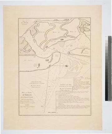
Port et Barre d'Amelia. de la Floride Orientale
Visual Materials
Kashnor notes, "Issued for the use of French navigators during the Revolution. It is a rare chart, taken from an English chart, showing the location of plantations." This map is a direct copy of Jacob Blamey's map, 105:094. Appeared in per RLIN record. Relief: no. Graphic Scale: Miles. Projection: Plane. Watermark: Chained Maltese cross lettering. Printing Process: Copper engraving. Verso Text: MS note: 101.
105:101 M
![Carte de la Floride Occidentale et Louisiane - La Peninsule at Golfe de la Floride ou Canal de Bahama avec les Isles de Bahama [two maps in one]](/_next/image?url=https%3A%2F%2Frail.huntington.org%2FIIIF3%2FImage%2F22APN4KVPDMF%2Ffull%2F%5E360%2C%2F0%2Fdefault.jpg&w=750&q=75)
Carte de la Floride Occidentale et Louisiane - La Peninsule at Golfe de la Floride ou Canal de Bahama avec les Isles de Bahama [two maps in one]
Visual Materials
Kashnor notes, "Copied from Jefferys' fine chart, the best chart of the time for navigators to Florida and the Mississippi. This was issued for the use of French allies during the Revolution." Appeared in reference from RLIN record. Compass rose. Ships on two routes.. Prime meridian: London, Ferro. Relief: pictorial. Graphic Scale: No. Projection: Mercator. Watermark: Chained Maltese cross lettering. Printing Process: Copper engraving. Other Features: Art Work. Verso Text: MS notes: 28 29 98.
105:098 M
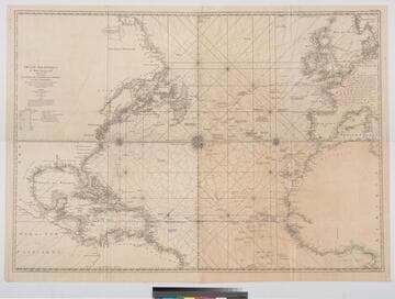
Océan Atlantique et Mers Adjacentes en quatre feulles Contenant Les Côtes de l'Europe, de l'Afrique et de l'Amérique
Visual Materials
Kashnor notes, "a scarce map [after Jefferys] issued for the use of the French allies during the Revolution." One map in two sheets. Navigational notes, compass variations, various voyages. Author and appeared in references from RLIN record [this record for upper section] Three compass roses. . Prime meridian: London, Ferro. Relief: no. Graphic Scale: Leagues, Marine. Projection: Mercator. Watermark: Chained Maltese Cross Dupys Moyen(?). Printing Process: Copper engraving. Verso Text: MS notes : 34 (upper) 56 (lower) 63.
105:063 M
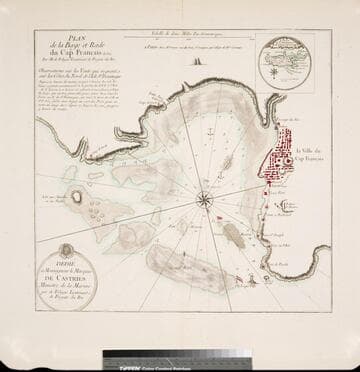
Plan de la Baye et Rade du Cap Francais dessiné Par M. de Foligne Lieutenant de Fregate du Roi
Visual Materials
Kashnor notes, "A rare map, giving a map of the town and all the old forts to the Cape." Kashnor dates as ca. 1760, submap shows 1780. Sub-map: Carte de St. Domingue 1780. Relief: hachures. Graphic Scale: Miles. Projection: Plane. Watermark: Chained Maltese cross lettering. Printing Process: Copper engraving. Other Features: Sub-maps. Verso Text: MS note: 422.
105:422 M
Image not available
La Partie Meridionale de l'Amerique Appelée Terre Ferme ou se trouve Les Provinices ou Grands Gouvernemens de La Guiane et de La Nouvelle Grenade
Visual Materials
"cette derniere Province Subdivée en Popaya, Cartagene, Ste. Marthe, Rio de la Hacha, Venezuala, et Nouvelle Andalousie. Le Pays et Le Cours de la Riviere des Amazones Au Sud de cette Carte, Comme l'Istme de Panama au Nord-Ouest, si trouvent assé bien detaillez. Dresée Sur les Diverses Relations des Flibustiers et Fameux Voyageurs Par. N. de Fer. Geographe de sa Majesté Catolique 1719." Cartouche: vined. . Relief: pictorial. Graphic Scale: Leagues. Projection: Cylindrical. Watermark: Chained maltese cross lettering. Printing Process: Copper engraving. Other Features: Cartouche. Verso Text: MS note: 914.
105:914 M