Visual Materials
Plan de la Baye et Rade du Cap Francais dessiné Par M. de Foligne Lieutenant de Fregate du Roi

You might also be interested in

Port de Rhode Island et Narraganset Baye à la Requête du Vicomte Howe par le Chevalier des Barres, Londres 1776, traduit de l'Anglais, et augmenté d'apres celui de Blaskowitz
Visual Materials
Kashnor notes, "A very rare map, issued for use of the commanders of the French warships during the Revolution." One map in two sheets, with insert map of Newport. Submap of Newport, RI. Prime meridian: GM. Relief: hachures. Graphic Scale: Miles. Projection: Mercator. Watermark: Chained Maltese cross lettering. Printing Process: Copper engraving. Other Features: Sub-maps. Verso Text: Upper MS note:11. Lower sheet MS notes: 12 144.
105:144 M

Carte du Canada ou de la Nouvelle France et des Decouvertes quiy ont été faites Dresée sur plusieurs Observations et sur un grand nombre de Relations imprimées ou manuscrites Par Guillaume Del'Isle de l'Academie Royale des Sciences et Premier Geographe du Roy
Visual Materials
Kashnor notes, " Indicates the location of the Indian nations and the French forts, especially those taken from the Hudson's Bay Company. It locates the wintering place, on the Bay, of Jean Munck in 1619. This is one of the earliest issues of Delisle's map." See also 105:431, 105:432 for later versions. Cartouche with natives.. Prime meridian: Ferro?. Relief: pictorial. Graphic Scale: Miles, leagues. Projection: Pseudocylindrical. Watermark: Chained Maltese cross lettering. Printing Process: Copper engraving. Other Features: Cartouche. References: McCorkle 703.5. Verso Text: MS notes: 432.
105:433 M
Image not available
Partie des Côtes de Labrador Depuis le Cap Charles à la Baye de Sandwich
Visual Materials
Kashnor notes, "A scarce map, issued for the use of French navigators during the Revolution." This map appears to be half of the RLIN record cited. Inset Riviere de Uo.. Relief: no. Graphic Scale: Leagues. Projection: Plane. Watermark: Crowned Maltese cross lettering. Printing Process: Copper engraving. Other Features: Sub-maps. Verso Text: MS note: 104.
105:104 M

Environs de Philadelphia par Seull et Heap, Publié á Londres par Faden en 1777
Visual Materials
Kashnor notes, " A very rare impression of the French map of Scull and Heap, issued for the use of the French allies in the Revolution." Relief: hachures. Graphic Scale: Miles. Projection: Plane. Watermark: Chained Maltese cross lettering. Printing Process: Copper engraving. Verso Text: MS note: 136.
105:136 M
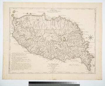
La Grenade Divisée par Paroisses Levée par ordre du Gouverneur Scott, Traduit de l'Anglais A Paris Chez le Rouge rue des Grands Augustins 1778 avec Privilege du Roi
Visual Materials
Kashnor notes, "The second issue, noting that D';Estaing attacked Port Royal in 1779." Prime meridian: Ferro, London. Relief: hachures. Graphic Scale: Leagues. Projection: Plane. Watermark: Chained maltese cross lettering. Printing Process: Copper engraving. Verso Text: MS note: 402.
105:402 M

Baye de la Delaware Aved les Ports, Sondes, Dangers, Bancs. &c. depuis les Caps Jusqu'a Philadelphie
Visual Materials
Kashnor notes, "A scarce chart issued for the use of the commanders of French ships-of-war and transports during the Revolution." Details sailing directions to port of Philadelphia. Relief: no. Graphic Scale: Miles, English, leagues, marine. Projection: Plane. Watermark: Chained Maltese cross lettering. Printing Process: Copper engraving.
105:089 M