Opening Hours
Daily: 10 A.M.–5 P.M.
Closed on Tuesdays
1151 Oxford Road
San Marino, CA 91108
Visual Materials

Daily: 10 A.M.–5 P.M.
Closed on Tuesdays
1151 Oxford Road
San Marino, CA 91108

Visual Materials
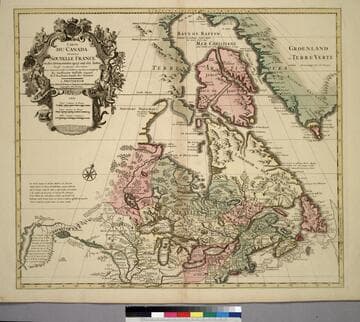
Kashnor notes, "The map still shows the territory around the southern part of Hudson's Bay as French territory, with Fort Nelson called Fort Bourbon, and Fort St. Louis on Moose River. The supposed Western Sea is taken from particulars furnished by La Houton." See 105:433 for earlier version, 105:432 for later. McCorkle identifes this as 1708 version. Cartouche with natives. Photocopy stored with map.. Prime meridian: Ferro?. Relief: pictorial. Graphic Scale: Miles, leagues. Projection: Pseudocylindrical. Watermark: C (symbol) I H (lettering). Printing Process: Copper engraving. Other Features: Cartouche. References: McCorkle 703.5. Verso Text: MS notes: Canada et Nouvelle France 105/431 Canada, ou la Nouvelle France. 3.
105:431 M
Image not available
Visual Materials
Kashnor notes, "This is the Châtelain map, taken from DeLisle. It locates only the French forts around Hudson's Bay, and shows a correct idea of the locations of the Indian tribes west of the Great Lakes; also shows La Houton's assumed location of the great River of the West, and the western sea beyond the range of mountains." Kashnor dates as ca. 1720. See 105:431 for another version, 105:433 for an earlier version. Historical remarks replace of cartouche on 105:431 version.. Prime meridian: Ferro?. Relief: pictorial. Graphic Scale: Miles, leagues. Projection: Pseudocylindrical. Printing Process: Copper engraving. Verso Text: MS note: 432.
105:432 M
Visual Materials
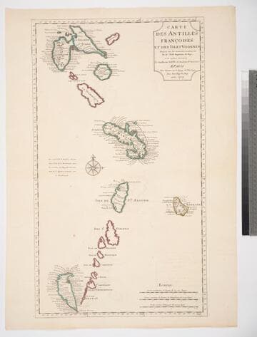
See 105:945 for another copy, 105:471M for a later copy. Prime meridian: Ferro. Relief: pictorial. Graphic Scale: Leagues. Projection: Cylindrical. Watermark: Chained maltese cross lettering. Printing Process: Copper engraving. References: Tooley, French Mapping of the Americas 54; Phillips 1055.. Verso Text: MS note: 721.
093:721 M
Image not available
Visual Materials
See 093:646M for a later copy by Buache, also 093:686M; for Homann copy, 093:682M. Note this is a reduced size copy with inferior engraving, see cartouche. Kashnor dates this copy as ca. 1720. Cartouche: Amazon warriors. Prime meridian: Ferro. Relief: pictorial. Projection: Pseudocylindrical. Watermark: Chained Maltese cross lettering. Printing Process: Copper engraving. Verso Text: MS notes: 682 30.
105:929 M
Image not available
Visual Materials
Kashnor notes, "Shows the Gulf of California only reaching as high as the Bona Guia, but without the definite termination; also shows New Holland and part of New Zealand, with the tracks of Mendana, Dampier, Olivier, Tasman, Pelsart, Magellan and le Maire." This appears to be a later state of the 1700 map, see 093:180. The slant of South America has been corrected eastward, some new names appear on the west coast of Africa, and a new mountain range in Siberia. Image is lighter than 1700 original. See also 093:181, 105:244 and 105:245 for later editions. Cartouche - figures representing four continents. Prime meridian: Ferro. Relief: pictorial. Projection: Dual Hemisphere. Watermark: Chained Maltese cross. Printing Process: Copper engraving. Other Features: Cartouche. References: Shirley 603. Verso Text: MS notes: 245.
105:245 M
Image not available
Visual Materials
Kashnor notes, "Shows the Gulf of California only reaching as high as the Bona Guia, but without the definite termination; also shows New Holland and part of New Zealand, with the tracks of Mendana, Dampier, Olivier, Tasman, Pelsart, Magellan and le Maire." Shirley shows this as first edition, 1700, note slant of South America's tip to the west. See also 093:181, 105:244 and 105:245 for later editions. Cartouche - figures representing four continents. Prime meridian: Ferro. Relief: pictorial. Projection: Dual Hemisphere. Watermark: Chained Maltese cross. Printing Process: Copper engraving. Other Features: Cartouche. References: Shirley 603. Verso Text: MS notes: 180 3.
093:180 M