Visual Materials
Mappe-Monde Dresée sur les Observations de Mrs. de l'Academie Royale des Sciences et quelques autres et sur les memoires les plus recens. A son Altesse Royale Monseigneur le Duc de Chartes
You might also be interested in
Image not available
Mappe-Monde Dresée sur les Observations de Mrs. de l'Academie Royale des Sciences et quelques autres et sur les memoires les plus recens. A son Altesse Royale Monseigneur le Duc de Chartes
Visual Materials
Kashnor notes, "Shows the Gulf of California only reaching as high as the Bona Guia, but without the definite termination; also shows New Holland and part of New Zealand, with the tracks of Mendana, Dampier, Olivier, Tasman, Pelsart, Magellan and le Maire." Shirley shows this as first edition, 1700, note slant of South America's tip to the west. See also 093:181, 105:244 and 105:245 for later editions. Cartouche - figures representing four continents. Prime meridian: Ferro. Relief: pictorial. Projection: Dual Hemisphere. Watermark: Chained Maltese cross. Printing Process: Copper engraving. Other Features: Cartouche. References: Shirley 603. Verso Text: MS notes: 180 3.
093:180 M

Mappe-Monde Dresée sur les Observations de Mrs. de l'Academie Royale des Sciences et quelques autres et sur les memoires les plus recens. Par M. de L'Isle
Visual Materials
Kashnor notes, "One of the earliest maps to show California with a continuous coastline, and showing the tracks of St. Antoine [1710], Mandana and Quir, Tasman, and other discoverers." This is a copy of L'Isle's 1700 map (093:180) with added border art, redone cartouche, the tip of South America corrected, the Solomon Islands moved. Kashnor dates as [1720] as does Shirley. This map shows corrections from 105:245 in Siberia, but the east coast of Korea is shown in the manner of the 1700 map. Name corrections in Africa on 105:245 do not appear. Compare with 105:244M dated 1720 with a less westerly trending California peninsula and Frisland no longer shown below Greenland. Route of the Mississippi and shape of Hudson's Bay follow the 1700 map, indicating this map may have been printed before the dated 105:244M copy and before the undated 105:245. Cartouche - figures representing four continents. Four submaps, arctic and antarctic polar views, one centered on Paris, another on Paris antipode. Merman and Mermaid with sailing vessels lower margin.. Prime meridian: Ferro. Relief: pictorial. Projection: Dual Hemisphere. Printing Process: Copper engraving. Other Features: CartoucheSub-maps. References: Shirley 603 (mentioned). Verso Text: MS notes: 181.
093:181 M
Image not available
L'Amerique Meridionale : dressée sur les observations de Mrs. de l'Academie Royale des Sciences & quelques autres, & sur les memoires les plus recens / par G. de L'Isle
Visual Materials
Kashnor notes, "Shows the Argentine provinces as 'Provinces de Rio de la Plata'." [Shows l'Isle's 1700 version of this map with westward tilting South America.] See also 093:610M. Alt. title from upper margin. Cartouche: Natives. Prime meridian: Ferro. Relief: pictorial. Graphic Scale: Leagues. Projection: Pseudocylindrical. Printing Process: Copper engraving. Verso Text: MS note: 836.
105:836 M
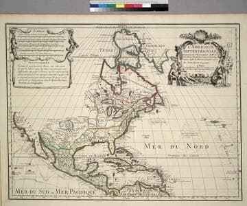
L'Amerique Septentrionale, Dresée sur les Observations de. Mrs. de l'Academie Royale des Sciences. & quelques autres, & sur les Memoires les plus recens
Visual Materials
Kashnor notes, " Shows the Gulf of California reaching only as far north as the Bona Guia River, the north-west coast has its limit at Cap Mendocin. It locates the Sierra Nevada Mountains, Port de Drak and New Albion, and also the tracks of Cortez, Drake, Olivier, Mendana and Gaetana. One of the best maps to show the geographical knowledge of California at the beginning of the 18th century." George Carhart of Osher Map Library confirms this map to be state 2, published in [1701]. See 093:160M for a later version of this map. Cartouche and figured scale bar. Includes Avertissement.. Prime meridian: Ferro. Relief: pictorial. Graphic Scale: Leagues, various. Projection: Pseudocylindrical. Watermark: Chained Maltese cross. Printing Process: Copper engraving. Other Features: CartoucheFigures . Verso Text: MS notes: 72 (on folded left edge); 159 Mus. Bk St. 93/159 25.
093:159 M

Carte du Canada ou de la Nouvelle France et des Decouvertes quiy ont été faites Dresée sur plusieurs Observations et sur un grand nombre de Relations imprimées ou manuscrites par Guillaume Del'Isle Geographe de l'Academie Royale des Sciences
Visual Materials
Kashnor notes, "The map still shows the territory around the southern part of Hudson's Bay as French territory, with Fort Nelson called Fort Bourbon, and Fort St. Louis on Moose River. The supposed Western Sea is taken from particulars furnished by La Houton." See 105:433 for earlier version, 105:432 for later. McCorkle identifes this as 1708 version. Cartouche with natives. Photocopy stored with map.. Prime meridian: Ferro?. Relief: pictorial. Graphic Scale: Miles, leagues. Projection: Pseudocylindrical. Watermark: C (symbol) I H (lettering). Printing Process: Copper engraving. Other Features: Cartouche. References: McCorkle 703.5. Verso Text: MS notes: Canada et Nouvelle France 105/431 Canada, ou la Nouvelle France. 3.
105:431 M
Image not available
Carte de la Terre Ferme du Perou, du Bresil et du Pays des Amazones, Dressée sur les Descriptions de Herrera de Laet, et des PP d'Acuna, wt M. Rodriquéz et sur plusiers Relations et Observations posterieures, Par Guillaume Del"Isle Premier Geographe du Roy de l'Academie Royale des Sciences
Visual Materials
See 093:646M for a later copy by Buache, also 093:686M for Homann copy, 105:929 for Covens & Mortier copy. Cartouche: Amazon warriors.. Prime meridian: Ferro. Relief: pictorial. Projection: Pseudocylindrical. Watermark: Chained maltest cross lettering. Printing Process: Copper engraving. Other Features: Cartouche. Verso Text: MS notes: 682 30.
093:682 M