Visual Materials
Chart of the Harbour of Boston, with the Soundings, Sailing-Marks and Other Directions
You might also be interested in

Chart of the Entrance to Hudson's River, from Sandy Hook to New York, with the Banks, Depths of Water, Sailing-marks, &ca
Visual Materials
Kashnor notes, "A scarce chart, issued during the early period of the American Revolution." Found in North-American pilot for New England, New York, Pensilvania (sic), Maryland, and Virginia 1777, per RLIN record. Relief: hachures. Graphic Scale: Miles, English. Projection: Plane. Watermark: Crowned fleur-di-lis. Printing Process: Copper engraving. References: Phillips 1209. Verso Text: MS note: 105.
093:105 M
![[Chart of the Harbour of Boston. Composed from different Surveys; but principally from that taken in 1769, by Mr. George Callendar, Late Master of His Majesty's Ship the Romney.]](/_next/image?url=https%3A%2F%2Frail.huntington.org%2FIIIF3%2FImage%2F22APN4KOZYQR%2Ffull%2F%5E360%2C%2F0%2Fdefault.jpg&w=750&q=75)
[Chart of the Harbour of Boston. Composed from different Surveys; but principally from that taken in 1769, by Mr. George Callendar, Late Master of His Majesty's Ship the Romney.]
Visual Materials
Map bears no title, title taken from accompanying remarks. Kashnor notes, "This was the special issue made for ships of war and transports at the outbreak of the American Revolution. The map is seldom found in green, and there is no record of the nautical remarks and map being found together as they were originally issued. Exceedingly rare." Nautical remarks in original blue binding filed with this map. As noted, stippled green shading is unusual Prime meridian: GM. Relief: shaded & pictorial. Graphic Scale: Miles, fathoms. Projection: Plane. Watermark: Crowned fleur-de-lis VI. Printing Process: Copper engraving. Verso Text: MS note: 986.
105:986 M

Plan of Amelia Island in East Florida - Part of Cumberland Island Georgia - Chart of the Mouth of Nassau River
Visual Materials
Kashnor notes, "A rare sheet of charts. It was issued for the use of navigators and captains of ships-of-war during the Revolution." See 105:095 for a French copy of this map. RLIN record corrects publication date to 1777, gives appeared in information. Three maps plus view of the entry to the St. Mary's River. . Relief: no. Graphic Scale: Miles. Projection: Plane. Watermark: Crowned fleur-di-lis WF. Printing Process: Copper engraving. Verso Text: MS notes: 105-100 31 013.
105:100 M
Image not available
General Chart of the Island of Newfoundland with the Rocks & Soundings
Visual Materials
"Drawn from Surveys taken by Order of the Right Honourable the Lords Commissioners of the Admiralty. By James Cook and Michael Lane Surveyors and Others." Appeared in information from RLIN record. Prime meridian: London. Relief: pictorial. Projection: Cylindrical. Watermark: Crowned fleur-di-lis VI. Printing Process: Copper engraving. Verso Text: MS note: 557.
105:557 M
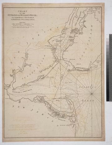
Chart of the Entrance of Hudson's River, from Sandy Hook to New York, with the Banks, Depths of Water, Sailing-marks &ca
Visual Materials
Kashnor notes, " The first issue of this chart. It was reissued in 1800 by Laurie & Whittle, but without date." Relief: hachures. Graphic Scale: Miles. Projection: Plane. Watermark: Crowned fleur-di-lis VI. Printing Process: Copper engraving. Verso Text: MS notes: 3 578.
105:578 M

Plan of the Island of St. John with the divisions of the Counties Parishes & the Lots as granted by Government likewise the Soundings round the Coast and Harbours
Visual Materials
Kashnor notes, "This is the first issue of Holand's map before it passed to Sayer and Bennett." Submap: Gulf of St. Laurence. Table: the Contents of the Respective Divisions of the Island of St. John. Cartouche: Fishing, farming view.. "Surveyed by Capt. Holland 1775." Prime meridian: London. Relief: no. Graphic Scale: Miles. Projection: Plane. Watermark: Crowned fleur-di-lis WF. Printing Process: Copper engraving. Other Features: Sub-mapsCartouche. Verso Text: MS notes: 754 4.
105:754 M